Arthur Remnants Push Offshore East Coast Friday With Low 10 Percent Development Chance as System Tracks Northeast Across Western Atlantic
CHARLESTON, SC — The remnants of Post-Tropical Cyclone Arthur, now a trough of low pressure producing scattered showers and thunderstorms over the southeastern United States, are expected to emerge offshore the East Coast by Friday afternoon, with forecasters monitoring only a low chance of further tropical or subtropical development over the next several days.
System Tracks Off the Carolina Coast
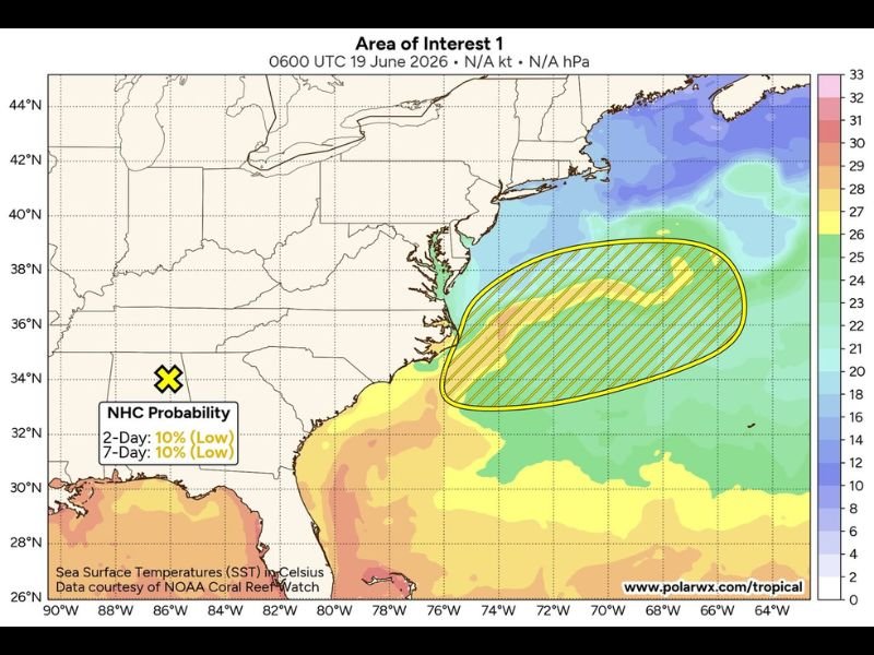
The National Hurricane Center’s monitoring area is centered off the coast of the Carolinas, with the disturbance expected to move offshore by Friday afternoon before continuing northeastward at approximately 20 mph across the Western Atlantic Ocean. The system’s current position places it near the Southeast coastline, with the highlighted area of interest extending from roughly North Carolina out into open Atlantic waters.
Environmental conditions surrounding the system are described as only marginally conducive for development, meaning any organization that does occur is expected to remain limited in both intensity and duration.
Development Chances Remain Low Through the Weekend
The National Hurricane Center has assigned the system a 10 percent chance of development over both the 2-day and 7-day periods, classifying the overall potential as low. Conditions could become marginally more favorable for subtropical or tropical development tonight or Saturday as the disturbance continues its northeastward trajectory away from the coastline.
Ensemble model tracking shows the system’s probable path extending well off the Atlantic Seaboard, with the highest-probability corridor running parallel to the coast before curving further out to sea over the following days.
Rest of the Atlantic Basin Remains Quiet
Outside of this single area of interest, the broader Atlantic basin remains quiet, with no other systems currently being monitored for development. This keeps overall tropical activity limited to the lingering effects of Arthur’s remnant energy as it transitions away from the Southeast coast.
Coastal Impacts Expected to Diminish
As the disturbance moves offshore and accelerates northeastward, lingering shower and thunderstorm activity across the southeastern United States is expected to gradually decrease through the day. Coastal areas of the Carolinas may still see periodic rain bands before the system fully clears the region by early Friday evening.
For continuing coverage of tropical systems and weather impacts across the United States, visit SaludaStandard-Sentinel.com.