3 Inch Rainfall Soaks Northwest Ohio and Indiana Over 48 Hours With Tornado Warning Damaging Winds and Widespread Storm Reports
TOLEDO, OH — A significant 48-hour rainfall event swept across northwest Ohio and northeast Indiana, dropping widespread precipitation totals ranging from less than 0.25 inches to over 3 inches across the region. Despite an active severe weather threat overnight, the event ultimately produced a best-case scenario with instability kept remarkably low by steady, continuous rain.
Highest Totals Concentrated in Western Counties
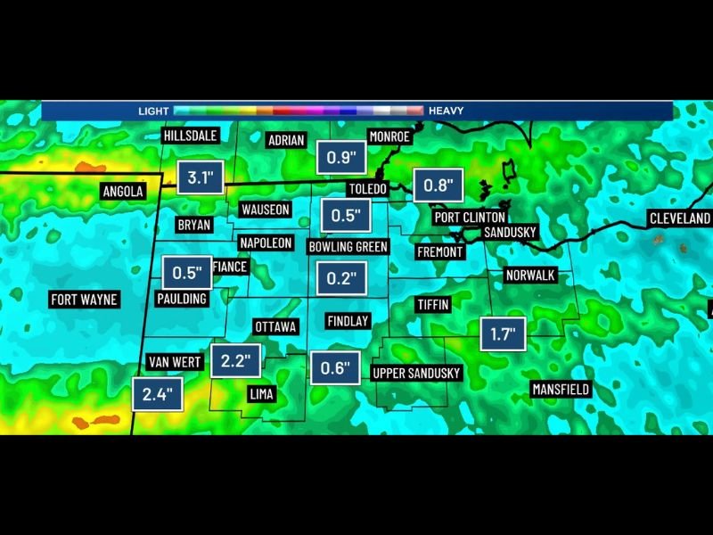
The heaviest rainfall was recorded in the far western portions of the region, with Angola, Indiana logging the highest observed total at 3.1 inches over the 48-hour period. Van Wert, Ohio recorded 2.2 inches, while areas near Lima came in at 2.4 inches, confirming a pronounced west-to-east gradient in precipitation intensity across the affected zone.
Totals dropped off considerably moving eastward, with Toledo recording 0.5 inches, Bowling Green coming in at 0.2 inches, and Adrian at 0.9 inches. The variation highlights how localized tropical-style training bands can produce dramatically different totals across short distances.
Severe Weather Threat Remained Minimal Overnight
Although a tornado warning was issued at some point during the event, severe weather reports overnight were described as minimal overall. A few damaging wind reports were confirmed across the area, but no widespread structural damage or significant severe weather outcomes materialized from the system.
The steady, persistent nature of the rainfall played a direct role in suppressing atmospheric instability, keeping convective development limited and preventing the kind of explosive storm activity that forecasters had monitored as a possibility heading into the overnight hours.
Eastern Zones See Lighter But Notable Accumulations
Communities further east recorded more modest but still meaningful totals. Fremont and the surrounding area logged 1.7 inches, Port Clinton and Sandusky saw 0.8 inches, and Monroe came in at 0.8 inches as well. Findlay recorded 0.6 inches and Upper Sandusky 0.6 inches, reflecting the lighter but consistent rainfall that extended across central Ohio communities.
Fort Wayne and Paulding area locations recorded around 0.5 inches, rounding out a broad precipitation footprint that stretched across multiple counties in both states.
Flood and Road Impacts Across the Affected Area
Rainfall totals exceeding 2 inches in several counties raised concerns about ponding on roadways and poor-drainage flooding in low-lying areas. Residents across Van Wert, Lima, and Angola zones were urged to exercise caution on area roads following the prolonged rainfall event, which saturated already-stressed soils across the region.
For continuing coverage of severe weather events and precipitation impacts across the United States, visit SaludaStandard-Sentinel.com.