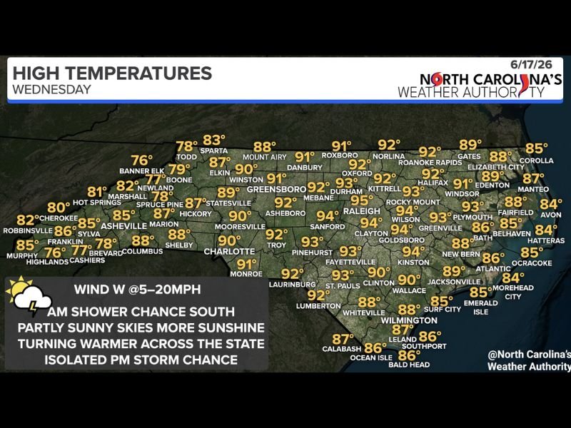
Warming Temperatures Return to North Carolina Wednesday With Highs Reaching 95 Degrees Near Raleigh as Morning Coastal Showers Clear for Partly Sunny Skies
RALEIGH, NC — North Carolina is warming back up Wednesday, June 17, after recent cooler days, with high temperatures climbing into the 80s and 90s across most of the state under partly sunny to mostly sunny skies, a few morning showers clearing from the southeast coast early, and only an isolated thunderstorm chance returning during the afternoon and evening hours.
Morning Conditions
A few showers are possible early Wednesday morning across southeastern and eastern North Carolina, particularly closer to the coast. These early showers are expected to clear through the morning hours, giving way to decreasing cloud cover and increasing sunshine across the state through midday. Western and mountain communities will start the day dry with partly sunny skies already in place.
Statewide Temperature Breakdown
North Carolina’s Weather Authority high temperature data for Wednesday shows the warmest readings concentrated across the central Piedmont and Raleigh corridor. Raleigh reaches 95°F with Mebane hitting 95°F as well, while Durham climbs to 93°F and Kittrell and Rocky Mount reach 93 to 94°F across the northeastern Piedmont.
Charlotte tops out at 90°F with Greensboro at 89°F and Statesville at 87°F across the western Piedmont. Fayetteville and Pinehurst reach 93°F in the south-central region, while Goldsboro climbs to 94°F and Kinston hits 94°F across the eastern counties.
Mountain communities remain the coolest, with Boone at 77°F, Banner Elk at 76°F, and Murphy at 85°F through the afternoon. The coast stays in the mid to upper 80s, with Wilmington reaching 87°F and the Outer Banks communities from Corolla through Hatteras holding in the 84 to 85°F range under sea breeze influence.
Afternoon and Evening Storm Chance
Despite the mostly dry and sunny Wednesday setup, an isolated thunderstorm cannot be ruled out during the afternoon and evening hours as daytime heating peaks across the Piedmont and central regions. Coverage will remain very limited, with the vast majority of locations staying dry through the entire day.
Westerly winds at 5 to 20 mph will continue pushing warmer and slightly drier air across the state through the afternoon, reinforcing the warming trend heading into the rest of the week.
For continuing coverage of North Carolina weather across the United States, visit SaludaStandard-Sentinel.com.