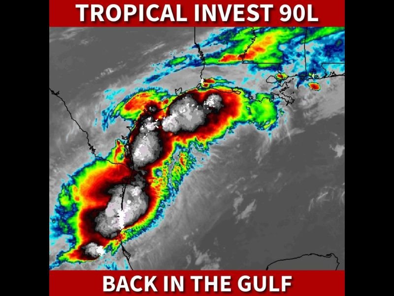
Invest 90L Likely to Become Tropical Storm Arthur Before Landfall in Louisiana Wednesday With Over a Foot of Rain Threatening South Central Louisiana and Mississippi
NEW ORLEANS, LA — Tropical Invest 90L has re-entered the Gulf of Mexico and is expected to become Tropical Storm Arthur before making landfall along the Louisiana coast Wednesday night, bringing a significant and potentially catastrophic heavy rain and flood threat to south-central Louisiana and Mississippi with over a foot of rainfall possible where the heaviest rain bands set up through Thursday morning.
Invest 90L Returns to the Gulf
Satellite imagery shows Invest 90L back in the Gulf of Mexico with an expansive and active convective signature, featuring intense red and white deep convective towers wrapped around a broad circulation center. The system’s structure has become increasingly organized following its re-emergence into the warm Gulf waters, providing the energy needed for rapid development toward tropical storm status ahead of Wednesday night’s anticipated Louisiana landfall.
Tropical storm watches and warnings along with an official NHC cone are expected to be issued later Tuesday as the system continues organizing and the track becomes more defined.
The Catastrophic Rain Threat
The primary and most dangerous threat from this system is not wind but rainfall. Forecasters express growing concern over an extreme heavy rain and flooding scenario for south-central Louisiana and Mississippi Wednesday night into Thursday morning. Over a foot of rain is forecast to fall across locations where the heaviest rain bands set up — a total that would produce life-threatening flash flooding and significant river flooding across the affected region.
The overnight timing of the heaviest rainfall dramatically increases the danger, as residents may be asleep when the most intense rain bands move through and flood waters rise rapidly.
Communities Most at Risk
South-central Louisiana sits directly in the crosshairs of the heaviest rainfall threat, with communities across the region facing the possibility of catastrophic flooding if model data verifies. Mississippi, particularly the southern half of the state, faces a significant flood threat as the system’s rain bands spread northeast of the landfall point through Thursday morning.
What Residents Should Do Now
Residents across south-central Louisiana and southern Mississippi should prepare for flooding immediately — moving vehicles to higher ground, gathering emergency supplies, and identifying evacuation routes before Wednesday evening.
For continuing coverage of Tropical Invest 90L and Gulf Coast flooding threats, visit SaludaStandard-Sentinel.com.