Stormy Pattern Builds Across Alabama Sunday With Heat Index Near 100 Degrees Ahead of Strong Storms Moving Southeast Through Birmingham and Tuscaloosa This Evening
BIRMINGHAM, AL — A stormy pattern is taking hold across Alabama this week, with leftover morning showers giving way to another period of very hot and steamy conditions Sunday, highs near 90°F and heat index values approaching 100°F, before scattered storms develop to the northwest by 4 p.m. and drop southeast through Birmingham, Tuscaloosa, and surrounding communities this evening with strong winds and frequent lightning possible.
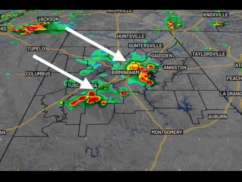
Sunday Radar and Storm Track
First Alert Weather forecast radar valid Sunday at 7 a.m. shows active storm cells already developing across Mississippi near Jackson and Memphis, with white arrows indicating a southeast track toward Alabama. By the afternoon and evening, this activity is expected to organize and push directly through the Birmingham metro and Tuscaloosa, with additional forecast radar frames showing storm cores tracking from the Columbus and Tupelo corridor through Birmingham, Gadsden, and Anniston as the evening progresses.
Some of Sunday evening’s storms could become strong, with gusty winds and frequent lightning as the primary hazards across the affected corridor.
Tuesday Brings Relief and More Rain
A frontal boundary is expected to stall nearby Monday, bringing off-and-on showers and scattered storms returning by Monday afternoon and continuing into Tuesday. The heaviest rain during this period looks to set up over the southern half of the Alabama coverage area, though radar trends will continue to be monitored for adjustments.
Tuesday brings a noticeable temperature drop, with highs near 80°F representing a significant break from Sunday’s near-90°F heat and oppressive heat index values.
Midweek Lull Before Thursday-Friday Return
Rain and storm coverage backs off Wednesday, providing a brief respite. However, activity increases again Thursday and Friday as the atmosphere has a chance to heat back up before storms arrive. Tropical moisture from a disturbance over the Gulf combining with a stalled frontal boundary will mean heavy rain at times for portions of Alabama during this Thursday-Friday window.
What to Expect This Week
Overall, Alabama should brace for an unsettled and potentially quite stormy stretch heading into next week, with conditions varying significantly day to day as multiple weather features interact across the region.
For continuing coverage of Alabama weather and storm threats across the United States, visit SaludaStandard-Sentinel.com.