Shower and Storm Chances Rising Through the Day Across the Illinois and Wisconsin Stateline Monday as Upper Level Low Pressure Pushes Temperatures to the Low 80s by Afternoon
ROCKFORD, IL — A warm, muggy, and occasionally unsettled Monday is underway across the Illinois-Wisconsin Stateline region on June 8, with shower and storm chances starting spotty and hit-or-miss in the morning before growing exponentially through the afternoon and evening as an upper-level low pressure system continues tracking toward the area.
Morning Conditions
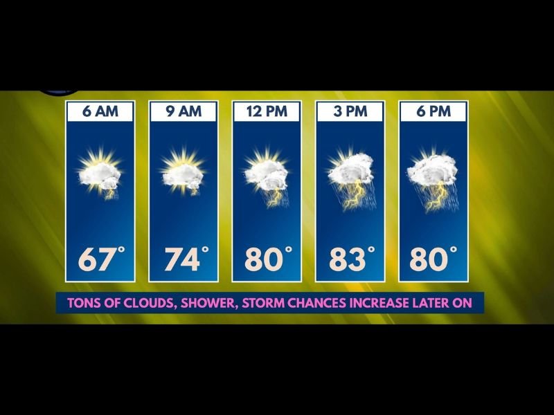
The day begins on a partly cloudy note with temperatures starting at 67°F at 6 a.m. and climbing steadily through the morning hours. By 9 a.m. temperatures reach 74°F under a mix of sun and increasing clouds. A few spotty showers or storms are possible early in the day, with the greatest early chances found west of Rockford where the approaching upper-level low will have its first influence on the region.
Cloud cover will help keep temperatures from spiking dramatically, though humidity will remain noticeable throughout the day and into the evening hours.
Afternoon and Evening Storm Threat
Storm chances grow significantly through the afternoon and evening as the upper-level low pressure system churns closer to the Stateline. Temperatures peak at 83°F by 3 p.m. before easing back to 80°F by 6 p.m. as cloud cover thickens and storm activity increases across the area.
The noon through evening window carries the highest storm probability, with shower and thunderstorm coverage becoming more widespread areawide rather than the isolated hit-or-miss pattern of the morning. Residents west of Rockford should be particularly attentive through the midday hours as that corridor faces the earliest and most consistent storm chances.
Severe Weather Outlook
Forecasters remain generally unconcerned about significant severe weather prospects for Monday’s storm activity, which limits the primary threat to nuisance rainfall, lightning, and gusty winds within stronger cells. However, the pattern becomes more concerning heading into the Wednesday and Thursday timeframe, when conditions could support a more organized severe weather threat across the region.
Residents should stay informed as the week progresses, as that midweek window will require close monitoring.
What to Expect the Rest of Today
Anyone with outdoor plans Monday afternoon across the Rockford area and surrounding Stateline communities should be prepared for storms to develop rapidly after noon. Keep weather alerts active on mobile devices and be ready to move indoors quickly as conditions can change fast under an approaching upper-level low.
For continuing coverage of Stateline weather and storm threats across the United States, visit SaludaStandard-Sentinel.com.
Author: Saluda Standard-Sentinel Team | Category: US News