Scattered Storms and Surging Heat Grip North Carolina Monday With Highs Reaching 95 Degrees Across Central and Southern Sections and a Backdoor Front Cooling the Northeast
RALEIGH, NC — North Carolina is starting the week of June 8 with a mix of building heat, scattered shower and thunderstorm chances, and a backdoor cold front keeping temperatures noticeably cooler across the northeastern corner of the state, creating a sharp temperature divide from west to east through Monday.
Temperature Breakdown Across the State
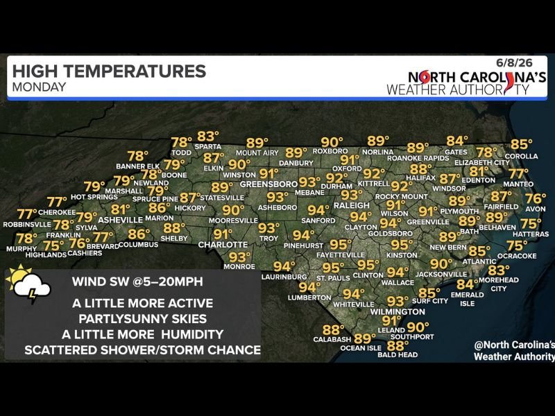
High temperatures Monday will range widely depending on location. Central and southern portions of the state will bear the brunt of the heat, with Fayetteville, St. Pauls, Clinton, and Kinston all reaching 95°F. Raleigh will top out near 93°F, while Charlotte climbs to 91°F and Greensboro hits 93°F.
Meanwhile, a backdoor front pushing in from the northeast will keep temperatures significantly cooler across northeastern North Carolina, with Roanoke Rapids holding in the upper 80s and coastal communities like Corolla, Manteo, and Hatteras remaining in the mid to upper 70s through the afternoon.
Storm Chances Through the Afternoon and Evening
Partly sunny skies will dominate the morning hours statewide, but shower and thunderstorm development is expected to increase through the afternoon and evening — particularly across western North Carolina and along the I-85 corridor. Isolated storm chances extend into central and eastern sections as well, though coverage will be more limited away from the western half of the state.
Southwest winds at 5 to 20 mph will help transport additional moisture into the region through the day, contributing to slightly elevated humidity levels compared to recent days and fueling storm development where instability is sufficient.
Coastal and Mountain Conditions
Mountain communities across western North Carolina will see highs ranging from the mid-70s at the highest elevations near Banner Elk and Robbinsville to the mid-80s in Asheville and Hickory. The coast will remain relatively comfortable with sea breeze influence keeping temperatures in the mid to upper 70s from Hatteras south through Ocracoke and the Outer Banks.
Residents across the Piedmont and southern regions should stay hydrated and limit prolonged outdoor exposure during peak heating hours Monday afternoon.
For continuing coverage of North Carolina weather and severe storm events across the United States, visit SaludaStandard-Sentinel.com.