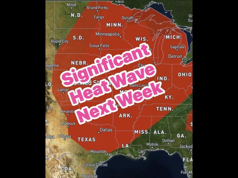
Significant Heat Wave to Blanket Texas and Much of the Central United States Next Week With Triple Digit Heat Index Values and Dangerous Sauna Like Conditions
DALLAS, TX — A powerful and expansive ridge of high pressure building across Texas and the central United States next week will deliver one of the most significant heat wave events seen across the region in quite some time, with triple digit heat index values expected during the afternoon hours as elevated humidity from recent rainfall combines with extreme temperatures to create dangerous sauna-like conditions across a massive geographic footprint stretching from Texas and the Gulf Coast northward through the Plains and into the upper Midwest.
Geographic Scope Is Remarkably Broad
The heat wave forecast map shows an enormous red shading zone encompassing virtually the entire central section of the United States from Texas and Louisiana northward through Arkansas, Missouri, Illinois, Indiana, Ohio, Michigan, Wisconsin, Minnesota, and the Dakotas, reflecting the truly regional and historically significant scale of the high pressure ridge forecast to dominate the nation’s midsection during the middle and latter portion of next week.
Cities spanning an extraordinary north to south distance including Houston, Dallas, Lubbock, Amarillo, Oklahoma City, Saint Louis, Chicago, Minneapolis, Sioux Falls, Fargo, and Detroit all fall within the heat wave footprint, underscoring how broadly the ridge of high pressure will assert its influence across the central and northern United States during the peak heat days.
Triple Digit Heat Index Values the Key Danger
The most dangerous and immediately life-threatening aspect of next week’s heat wave across Texas specifically is not the air temperature alone but the combination of extreme heat and elevated atmospheric moisture that will remain in place following recent heavy rainfall across the state.
Abundant moisture left behind by the recent wet pattern will keep humidity levels elevated throughout the heat wave period, causing heat index values to climb into the triple digits during afternoon hours and creating conditions where the human body faces serious physiological stress maintaining safe core temperature during extended outdoor exposure.
Hottest Conditions Arrive Mid to Late Week
Forecasters indicate the most intense and dangerous heat will build during the middle and latter portion of next week as the ridge of high pressure reaches its maximum strength and coverage across the region, with each successive day potentially bringing higher temperatures and more oppressive humidity combinations than the day before until the pattern eventually breaks.
Texas residents and those across the broader affected region are urged to stay well hydrated throughout the day, take frequent breaks when working outdoors, never leave children or pets unattended in parked vehicles under any circumstances, and identify air-conditioned spaces to retreat to during the most dangerous afternoon heat hours of the week ahead.
For continuing coverage of heat wave threats and dangerous weather conditions across the United States, visit SaludaStandard-Sentinel.com.