Level 2 Severe Weather Risk Upgraded Across Miami Valley Ohio With Damaging Winds the Primary Threat for Dayton Springfield and Troy Saturday Afternoon
DAYTON, OH — Most of the Miami Valley region of western Ohio has been upgraded to a Level 2 out of 5 severe weather risk for Saturday June 6, 2026 with damaging winds identified as the primary hazard during the afternoon round of storms, as showers and early storm activity already tracked through the region Saturday morning and forecasters monitor conditions for the more significant and organized afternoon severe weather threat across a broad corridor of communities.
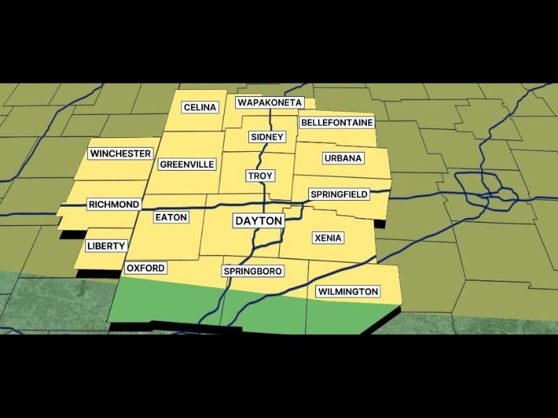
Level 2 Risk Zone Covers Broad Miami Valley Corridor
Storm Center 7 severe risk mapping for Saturday shows a substantial Level 2 yellow risk zone blanketing the majority of the Miami Valley region across western and west central Ohio, encompassing a wide collection of communities that will all face elevated damaging wind potential during the afternoon convective period.
Communities falling within the Level 2 severe risk zone include Dayton, Springfield, Troy, Sidney, Greenville, Eaton, Xenia, Urbana, Bellefontaine, Wapakoneta, Celina, Oxford, Springboro, Winchester, Richmond, Liberty, and the surrounding areas, reflecting the broad geographic footprint of the afternoon severe weather threat across the Miami Valley landscape.
Damaging Winds Are the Primary Concern
Forecasters have specifically identified damaging wind gusts as the dominant hazard within Saturday’s afternoon storm round across the Miami Valley, a threat profile consistent with a squall line or organized convective system capable of producing widespread straight line wind damage across the affected region during peak storm intensity.
Damaging wind gusts from organized afternoon storm systems can down trees and large branches, produce scattered power outages, damage roofing materials and outdoor structures, and create hazardous driving conditions across exposed roadways and highway corridors throughout the Miami Valley during the storm’s passage, making preparedness and situational awareness essential for all residents and travelers across the warned region.
Morning Activity Already Underway
The Saturday severe weather story began well before the afternoon peak threat window, with showers and early storm activity already moving through portions of the Miami Valley during the morning hours and requiring active radar monitoring from meteorologists tracking the developing and evolving storm pattern across the region.
The presence of morning storm activity adds a layer of atmospheric complexity to the afternoon severe weather forecast, as the degree to which morning convection stabilizes or destabilizes the atmosphere will influence how organized and intense the afternoon storm round ultimately becomes across the Dayton and surrounding Miami Valley communities.
For continuing coverage of Ohio severe weather risks and storm impacts across the United States, visit SaludaStandard-Sentinel.com.