Tornado Warning Issued for Cherry County Nebraska Sandhills South of Merriman as Radar Confirms Classic Rotation Signature in One of America’s Most Remote Regions
MERRIMAN, NE — A tornado warning was issued for Cherry County, Nebraska after a dangerous and well-organized tornadic thunderstorm developed south of Merriman in the vast and sparsely populated Nebraska Sandhills region, with KLNX radar imagery captured at 9:17 PM showing a textbook and alarming rotation signature including a tight couplet of inbound and outbound velocity values confirming the presence of a dangerous rotating supercell capable of producing a significant tornado across one of the most remote and least monitored landscapes in the entire United States.
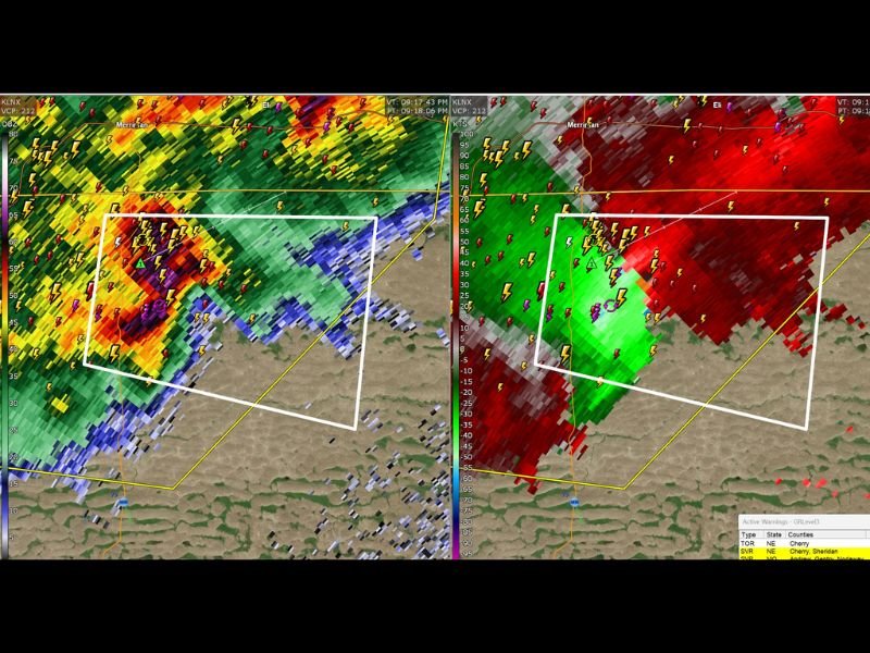
Radar Confirms Dangerous Rotation South of Merriman
Dual panel radar imagery shows two critically important pieces of information simultaneously, with the reflectivity panel on the left displaying deep red and magenta storm core values indicating an intense and well-organized supercell thunderstorm, while the velocity panel on the right reveals the definitive and unmistakable signature of tight rotational circulation with green inbound values immediately adjacent to red outbound values within the tornado warning polygon south of Merriman.
This classic couplet signature on velocity radar is precisely what meteorologists look for when issuing tornado warnings, as the tight pairing of opposing wind directions within a small geographic area indicates a concentrated and rapidly rotating column of air extending through the storm’s core that is either producing a tornado or carrying an imminent risk of doing so.
The Sandhills Tornado Documentation Problem
The Cherry County tornado warning highlights one of the most significant and underappreciated challenges in American severe weather documentation — the Nebraska Sandhills region covering Cherry County and surrounding areas represents one of the most sparsely populated and road-sparse landscapes in the continental United States, meaning that tornado events occurring across this terrain frequently go completely undocumented and unreported.
With population densities measured in fractions of a person per square mile across vast stretches of the Sandhills, a significant tornado can touch down, travel for miles, and dissipate without a single human witness ever observing it from the ground. Storm survey teams face enormous logistical challenges reaching affected areas across the roadless grassland terrain, and damage to the native grass and rangeland surface can be difficult to identify and assess without direct aerial or ground level inspection shortly after the event.
Cherry and Sheridan Counties Under Active Warnings
Radar warning data visible in the imagery confirms active tornado and severe thunderstorm warnings covering Cherry and Sheridan counties in Nebraska at the time of the radar capture, reflecting the broad scope of the dangerous atmospheric environment present across northwestern Nebraska during the evening storm event.
Residents across the extremely sparse communities in this region including Merriman and surrounding Cherry County are urged to take tornado warnings in this area with maximum seriousness regardless of the remote nature of the landscape, as even rural tornado events carry genuine life-threatening risk for anyone caught outdoors or in vulnerable structures within the warning area.
For continuing coverage of Nebraska tornado warnings and severe weather across the United States, visit SaludaStandard-Sentinel.com.