Arctic Low Drives Anomalous 40 to 45 MPH Wind Gusts and 15 Degree Temperature Drop Across Pennsylvania Saturday Morning Between 6 AM and 2 PM
HARRISBURG, PA — An anomalous Arctic low pressure system diving southward into New England is set to deliver unusually strong northerly wind gusts and temperatures running 10 to 15 degrees below seasonal norms across Pennsylvania on Saturday, with the peak wind window running from 6 AM through 2 PM and eastern portions of the state facing the greatest exposure to gusts approaching 40 to 45 miles per hour and isolated power outage potential.
A Statewide Wind Gradient From West to East
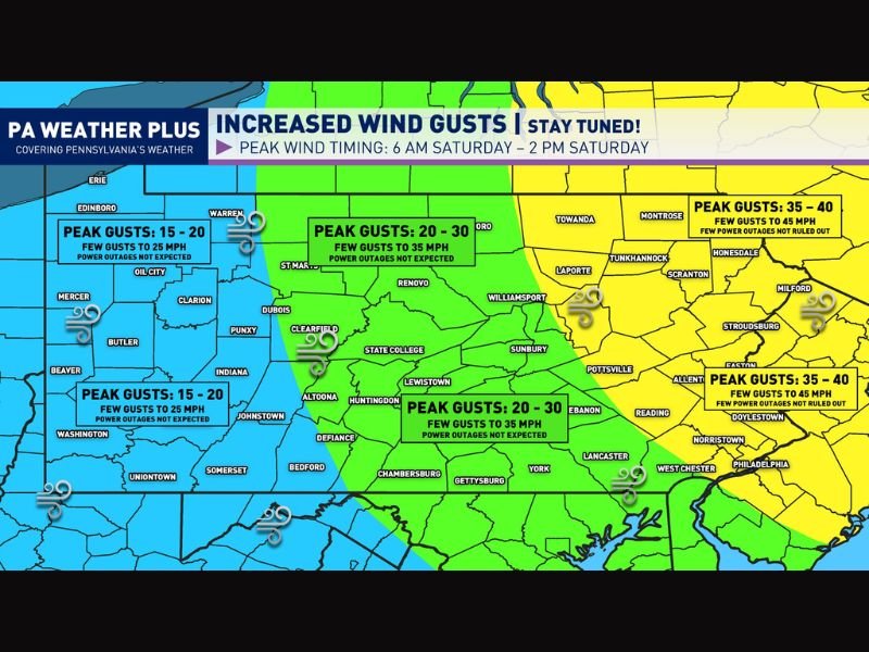
Forecast wind gust data depicts a clear and pronounced west to east gradient in wind intensity across Pennsylvania on Saturday, with impacts increasing significantly as you move from the western counties toward the eastern and northeastern portions of the state.
Western Pennsylvania including Erie, Mercer, Butler, Beaver, Washington, Uniontown, and Somerset can expect peak gusts of 15 to 20 miles per hour with a few isolated gusts reaching 25 miles per hour, a range that carries no meaningful power outage potential and represents a breezy but manageable situation for residents across that part of the state.
Central Pennsylvania Sees Moderate Winds
Central Pennsylvania communities including State College, Altoona, Huntingdon, Chambersburg, Gettysburg, York, Lancaster, and Williamsport fall within a moderate wind zone forecast to see peak gusts of 20 to 30 miles per hour with a few gusts potentially reaching 35 miles per hour.
Power outages are not expected across this central corridor, though the winds will be noticeably stronger than typical late May conditions and residents with outdoor activities planned for Saturday morning should account for breezy conditions throughout the peak wind timing window.
Eastern Pennsylvania Faces the Greatest Risk
The most significant wind impacts on Saturday will be concentrated across eastern and northeastern Pennsylvania including the Scranton, Stroudsburg, Milford, Honesdale, Towanda, and Philadelphia corridor, where peak gusts of 35 to 40 miles per hour are forecast with a few gusts potentially reaching 45 miles per hour during the morning hours.
Forecasters indicate that power outages cannot be ruled out across these eastern counties, particularly given that trees are in full leaf condition during late May, presenting dramatically increased wind resistance compared to bare winter trees and making even moderate gusts capable of snapping branches and downing utility lines.
Arctic Origin Makes This Event Unusual
The northerly origin of this wind event sets it apart from the thunderstorm-driven wind gusts that are more typical of strong wind events during the late spring and early summer season across Pennsylvania.
An Arctic low delivering 40 to 45 mile per hour gusts in late May is a genuinely anomalous pattern, with the same system responsible for delivering rare late spring snow to higher elevations across Maine and New Hampshire simultaneously as it pushes its influence southward into the mid-Atlantic region. For continuing coverage of wind events and weather impacts across the United States, visit SaludaStandard-Sentinel.com.