Heavy Rain Flood Threat Targets Ohio and Indiana Along I-70 Corridor With 1 to 2 Inch Per Hour Rainfall Rates Expected Overnight Into Wednesday Morning
INDIANAPOLIS, IN — A dangerous heavy rain setup is unfolding across Ohio and Indiana overnight into Wednesday morning, driven by a powerful low-level jet stream and high atmospheric moisture content. Forecasters warn this could produce significant flooding in vulnerable communities along and near the Interstate 70 corridor.
Weather Setup Driving the Threat
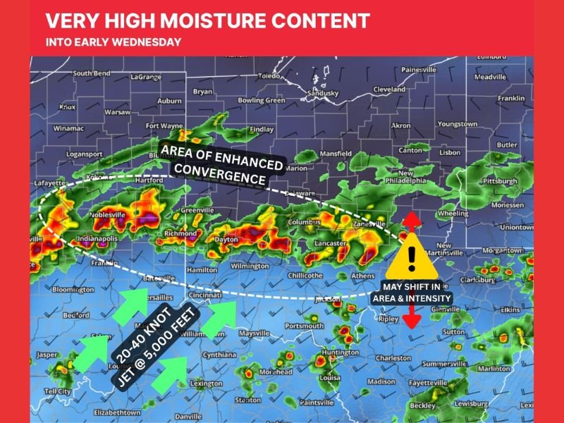
A 20 to 40 knot low-level jet stream positioned at approximately 5,000 feet is the primary engine behind this event, supplying a surge of deep moisture into the region while combining with atmospheric vorticity to force organized rain band development.
The configuration differs notably from a similar event earlier in the weekend, when banding ran in a southwest-to-northeast orientation. Tonight’s system will produce west-to-east oriented rain bands, a shift that alters which communities face the greatest exposure to prolonged, heavy rainfall.
Rainfall Rates and Flood Concern
Rainfall rates of 1 to 2 inches per hour are possible within the most active bands, a threshold that can rapidly overwhelm drainage systems and produce flash flooding in low-lying or flood-prone areas.
The axis of heaviest rain is broadly modeled near the I-70 corridor, though forecasters caution that exact placement and intensity carries meaningful uncertainty and may shift as the event evolves. Residents in flood-prone areas across central Indiana and central to eastern Ohio are urged to remain weather-aware and monitor conditions closely through Wednesday morning.
Timeline and Gradual Improvement
As the overnight hours progress, the low-level jet is expected to gradually shift to a more westerly direction, which will cause the rain bands to push southward and slowly decrease in intensity.
While this signals an eventual end to the heaviest rain, the timeline for improvement extends into Wednesday morning, leaving several hours of elevated flood risk across the affected region. Conditions should stabilize as the atmospheric setup winds down following the band displacement.
For continuing coverage of severe weather events and critical storm analysis across the United States, visit SaludaStandard-Sentinel.com.