Excessive Rainfall Outlook Issued for Ohio Friday May 22 With 1 to 2 Inches of New Rain Possible on Already Saturated Soils Raising Minor Flooding Concerns Into Early Saturday
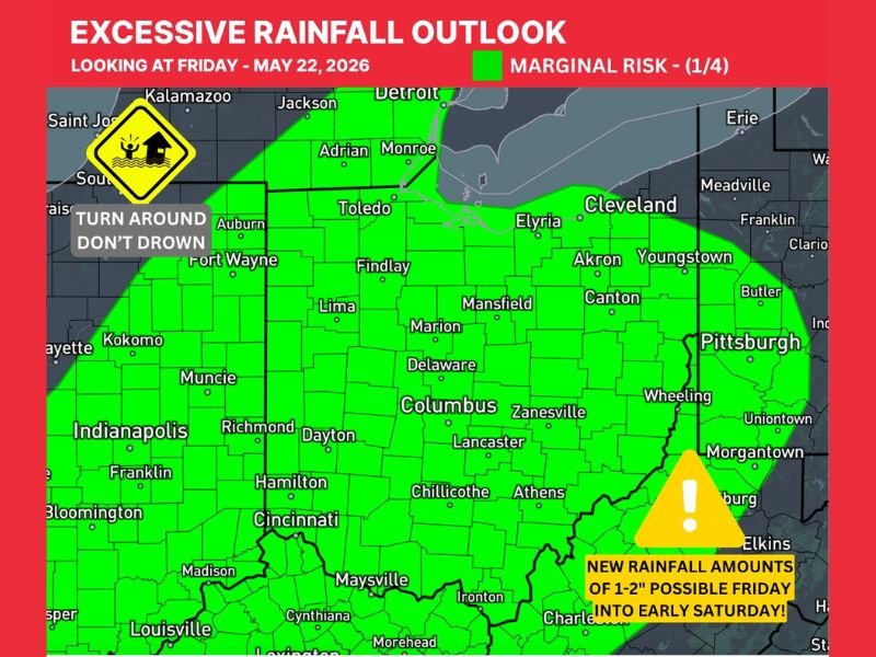
COLUMBUS, OH — A Marginal Risk Level 1 of 4 Excessive Rainfall Outlook has been issued for most of Ohio for Friday, May 22, 2026, as 1 inch or more of new rainfall is possible across the state on top of already saturated soils. The outlook, issued at 9:30 PM on May 20, 2026, covers a broad green shaded zone stretching across virtually all of Ohio and into portions of surrounding states, with new rainfall amounts of 1 to 2 inches possible from Friday into early Saturday raising minor and nuisance flooding concerns statewide.
Marginal Excessive Rainfall Risk Covers Most of Ohio for Friday Into Early Saturday
The Excessive Rainfall Outlook map shows a Level 1 Marginal Risk zone blanketing the vast majority of Ohio, encompassing major communities including Cleveland, Columbus, Cincinnati, Toledo, Akron, Dayton, and Youngstown along with all surrounding counties. The green shading extends southward into portions of Kentucky and West Virginia and westward into Indiana, reflecting the broad geographic reach of the incoming rain system expected to impact the region from late Friday into the early Saturday morning hours.
Uncertainty remains regarding the exact amounts and location of the heaviest rainfall totals within the outlined risk zone, making the monitoring of updated forecasts through Friday critically important for communities across the state.
Saturated Soils Increase Flood Risk as 1 to 2 Inches of New Rain Approaches
The primary concern driving the Excessive Rainfall Outlook for Ohio is the combination of incoming rainfall totaling 1 to 2 inches on top of soils that are already saturated from recent precipitation across the region. When soils reach saturation, their capacity to absorb additional rainfall is significantly reduced, meaning even moderate rainfall totals can produce disproportionate surface runoff, elevated stream levels, and localized flooding across low lying areas, poor drainage zones, and flood prone communities statewide.
Minor and nuisance flooding is considered possible across Ohio should the anticipated rainfall totals verify across the state during the Friday into early Saturday window, with the heaviest totals carrying the greatest flooding potential wherever they ultimately fall within the outlined risk area.
Ohio Residents Urged to Monitor Updates and Avoid Flooded Roadways Through the Weekend
All Ohio residents are encouraged to monitor updated excessive rainfall and flood watch information through Friday as the incoming rain system approaches the state. The Turn Around Don’t Drown message remains the most critical flood safety guidance for any motorist encountering standing water or flooded roadways during and after the Friday rainfall event across the state.
Communities along rivers, streams, and in low lying areas across Ohio are urged to pay particular attention to local flood guidance as the combination of saturated soils and new rainfall creates elevated runoff and flooding potential through the Friday night and early Saturday morning hours.
For continuing coverage of flood risks and rainfall forecasts across the United States, visit SaludaStandard-Sentinel.com.