Slow Moving Storm Line With 60 MPH Wind Gusts Tracks Through Northeast Oklahoma Tuesday Morning With Tulsa Bartlesville and Owasso Among Communities in the Direct Path
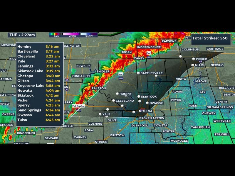
TULSA, OK — A slow moving line of storms tracking through southeast Kansas and far northeastern Oklahoma at 2:25 AM Tuesday is generating strong winds as the primary threat, with gusts up to 60 miles per hour possible as the system pushes southward through the region. The slow moving nature of this storm line means communities in its path will experience prolonged storm conditions rather than a quick passage, with 560 total lightning strikes already recorded as the system continues its overnight progression toward the Tulsa metropolitan area and surrounding communities.
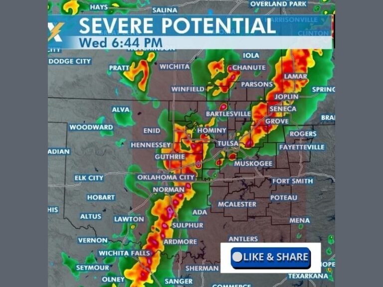
Slow Moving Storm Line Producing 60 MPH Gusts Across Southeast Kansas and Northeast Oklahoma
Radar imagery at 2:27 AM shows intense red and orange reflectivity returns concentrated along the storm line’s core as it tracks through the Chanute, Independence, Parsons, and Caney corridor of southeast Kansas into far northeastern Oklahoma. The storm line’s slow forward speed is the defining characteristic of this particular event, as lingering storm conditions over each community in the path will extend the wind, lightning, and rainfall threat for a prolonged period compared to faster moving systems.
A detailed storm arrival timeline has been issued for communities across northeastern Oklahoma, with Hominy expecting storm arrival at 3:16 AM, Bartlesville at 3:17 AM, and Cleveland at 3:23 AM as the line pushes southward through the region during the overnight and early morning hours.
Tulsa Owasso Skiatook and Surrounding Communities Face Early Morning Storm Arrival
The storm timing forecast shows a progressive arrival schedule across the northeastern Oklahoma corridor, with Yale at 3:27 AM, Skiatook Lake at 3:39 AM, Chetopa at 3:40 AM, and Nowata at 4:04 AM. Skiatook is forecast to see storms at 4:12 AM, while Sperry and Sand Springs follow at 4:25 AM and 4:34 AM respectively. Owasso is expected to receive the storm line at 4:44 AM, with Tulsa following closely at 4:45 AM as the slow moving system completes its southward track through the region.
The extended arrival window from just after 3:00 AM through nearly 5:00 AM across the northeastern Oklahoma corridor reflects the broad geographic reach of this slow moving storm line.
Residents Urged to Remain Weather Aware Through the Overnight and Early Morning Hours
Given the overnight timing and slow moving nature of this storm system, residents across all communities in the outlined path from Bartlesville and Cleveland southward through Skiatook, Owasso, and Tulsa are strongly urged to remain weather aware through the early morning hours. The prolonged storm window associated with slow moving systems means wind damage potential and lightning danger will persist over each community for an extended period after initial storm arrival.
Having active weather alert notifications enabled through the overnight period is particularly critical for residents across northeastern Oklahoma as this storm line continues its southward track through the pre-dawn hours.
For continuing coverage of overnight storm tracking and severe weather updates across the United States, visit SaludaStandard-Sentinel.com.