Staggered Storm Timing Moves Across Arkansas Tuesday From Early Morning Through Late Night With Rain and Thunder Expected Statewide and a Few Stronger Storms Possible
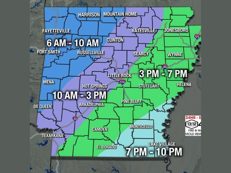
LITTLE ROCK, AR — A staggered storm system is set to move across Arkansas on Tuesday, with different regions of the state experiencing their storm windows at different times throughout the day and into the late night hours. The Arkansas Weather Network storm timing map breaks the state into four distinct color coded windows, providing residents with a general estimated arrival time for storm activity in their area as the system progresses from northwest to southeast across the state.
Northwest and North Central Arkansas Face the Earliest Storm Window From 6 AM to 10 AM
The earliest storm activity Tuesday is expected across northwest and north central Arkansas, with the blue zone covering communities including Fayetteville, Fort Smith, Harrison, Mountain Home, Russellville, and Clinton facing their primary storm window between 6:00 AM and 10:00 AM. Residents across this zone should expect rain and thunder during the morning hours with a few stronger storms possible as the system initiates across the northwestern portions of the state.
The purple zone covering central and south central Arkansas, including Little Rock, Hot Springs, Mena, Arkadelphia, and De Queen, follows with a storm window running from 10:00 AM through 3:00 PM as the system pushes southeastward through the midday hours.
Eastern and Southeast Arkansas See Afternoon and Evening Storm Windows
Eastern Arkansas communities including Jonesboro, Batesville, Searcy, Wynne, Stuttgart, and Helena fall within the green zone, facing their storm window between 3:00 PM and 7:00 PM as the system continues its southeastern progression through the afternoon hours. The light blue zone covering the far southeast corner of Arkansas including Monticello, Lake Village, and El Dorado sees the latest storm timing of 7:00 PM through 10:00 PM.
The overall severe weather risk for Tuesday is not considered high across Arkansas, with most locations expected to receive rain and thunder rather than significant severe weather.
Overall Severe Risk Remains Low but a Few Cranky Storms Worth Watching
While the severe weather threat for Tuesday remains generally low statewide, a few stronger and more active storm cells are possible across Arkansas throughout the day as the system moves through. Residents are encouraged to remain weather aware during their respective storm windows and monitor updated radar and forecast information as timing details become clearer through the day.
For continuing coverage of storm timing and weather forecasts across the United States, visit SaludaStandard-Sentinel.com.