Scattered Showers and Coastal Storms With Temperatures Crashing Into the 50s Hit North Carolina Monday as Backdoor Cold Front Tracks South Through the State Into Evening
RALEIGH, NC — A backdoor cold front is tracking southward through North Carolina on Monday, delivering scattered showers across northwestern and western areas during the morning before coastal shower and thunderstorm activity develops during the afternoon and evening, while temperatures fall sharply from the 60s and 70s down into the 50s and 60s from north to south as the front pushes through the region.
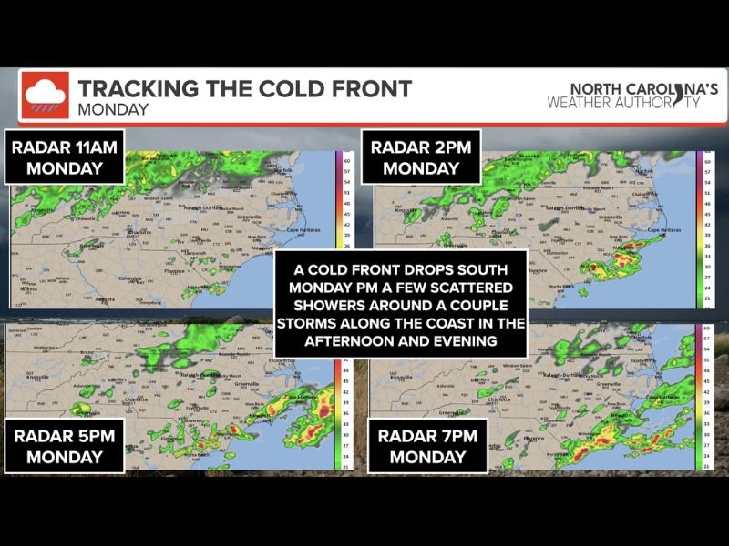
Morning Showers Across Northwest and Western Areas
A few isolated showers will be present across northwestern and western North Carolina during the morning hours ahead of the front’s main arrival. Radar progression imagery tracking the front at 11 AM shows scattered shower activity concentrated across the western tier of the state, with coverage remaining limited and non-threatening through the midday period before the front advances further south.
These morning showers will be brief and isolated, posing no significant threat to residents across the interior portions of North Carolina.
Coastal Storms Developing Afternoon Into Evening
The most active weather window falls during the afternoon and evening hours, when showers and thunderstorms develop along the North Carolina coast. Radar imagery valid for 5 PM and 7 PM Monday shows increasing storm coverage pushing toward Cape Hatteras and eastern communities as the front tracks southward.
An isolated severe storm with damaging winds cannot be completely ruled out along the coast, though the overall severe threat remains low across the state.
Sharp Temperature Drop Behind the Front
Temperatures reaching the 60s and 70s during Monday morning will fall into the 50s and 60s from north to south as the cold air pushes through behind the frontal boundary during the afternoon. Residents planning outdoor activities should prepare for noticeably cooler afternoon and evening conditions compared to the morning hours across both inland and coastal North Carolina communities.
For continuing coverage of severe weather events and critical storm analysis across the United States, visit SaludaStandard-Sentinel.com.