Tornado Watch Cancelled for Most of Central Alabama as Flooding Becomes Primary Overnight Threat With Southern Counties Still Under Watch Until 11 PM
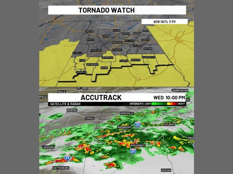
BIRMINGHAM, AL — The Tornado Watch covering most of Central Alabama has been cancelled as of the 10:00 PM Wednesday update, bringing significant relief to major population centers including Birmingham, Tuscaloosa, Anniston, and Gadsden. Southern counties however remain under an active Tornado Watch until 11 PM as the primary threat transitions toward localized flooding from repeated overnight rainfall.
Tornado Watch Lifted for Most of Central Alabama
The cancellation of the Tornado Watch across the majority of Central Alabama marks a meaningful shift in the overnight weather picture for millions of residents. Communities including Birmingham, Jasper, Cullman, Oneonta, Pell City, Talladega, Tuscaloosa, and Alexander City have all been removed from the active watch boundary.
This indicates that meteorologists are no longer tracking conditions sufficiently favorable for tornado development across those areas. The stronger storm cells responsible for the earlier tornado threat have progressed beyond the region, allowing forecasters to scale back the most urgent alert level across central portions of the state.
Southern Counties Remain Under Active Watch Until 11 PM
Despite the broader cancellation, a corridor of southern Alabama counties continues to face elevated tornado risk through 11 PM Wednesday. The active watch zone encompasses communities including Demopolis, Eutaw, Greensboro, Marion, Centreville, Clanton, and Rockford.
Atmospheric conditions across these southern counties still support the possibility of tornado development through the late evening hours. Residents in this zone are urged to maintain full situational awareness and have shelter plans ready until the watch officially expires for their specific location.
Flooding Now the Dominant Overnight Concern
With the tornado threat diminishing across most of the region, forecasters have shifted their primary concern to localized flooding as multiple additional rounds of heavy rain and thunderstorms are expected overnight. Radar imagery at 10:00 PM Wednesday shows widespread heavy precipitation stretching from the Jackson, Mississippi area through Birmingham and toward Montgomery.
Areas that have already received significant rainfall through the evening face the greatest flooding risk as additional precipitation accumulates on already saturated ground. The repeated nature of these overnight rain bands makes flash flooding a serious and sustained concern well beyond the expiration of the tornado watch.
Residents Urged to Avoid Flood-Prone Areas Overnight
Alabama residents across both cleared and still-active watch zones are advised to avoid low-lying roadways and stay alert to any flash flood warnings issued for their county. Driving through standing or moving water remains one of the leading causes of weather-related fatalities during overnight flood events.
Conditions across the state are expected to remain unsettled through the overnight hours, and residents should keep emergency alert systems active until forecasters confirm a full end to the severe weather and flooding threat across the region.
For continuing coverage of severe weather events and critical storm analysis across the United States, visit SaludaStandard-Sentinel.com.