Tornado Watch Continues for Metro Atlanta as Flood Threat Builds Overnight With Up to 2 More Inches of Rain Likely After Watch Cancelled for Far North Georgia
ATLANTA, GA — A Tornado Watch remains active for the metro Atlanta region as of 10:30 PM Wednesday, even as the same watch has been cancelled for far North Georgia following the southward shift of stronger storm cells, with the overnight threat now transitioning toward dangerous flooding from very heavy rainfall across the greater Atlanta area.
Watch Cancelled for North Georgia as Storms Move South
The Tornado Watch that had been covering far North Georgia was cancelled during the 10:30 PM update as the more powerful storm cells tracked southward away from that region. Communities including Blairsville and Ellijay, which had faced elevated tornado risk earlier in the evening, now sit outside the active watch boundary. However, the same southward movement that brought relief to northern communities has concentrated the severe weather threat directly over the heavily populated metro Atlanta corridor.
Tornado Watch Remains Active Over Metro Atlanta
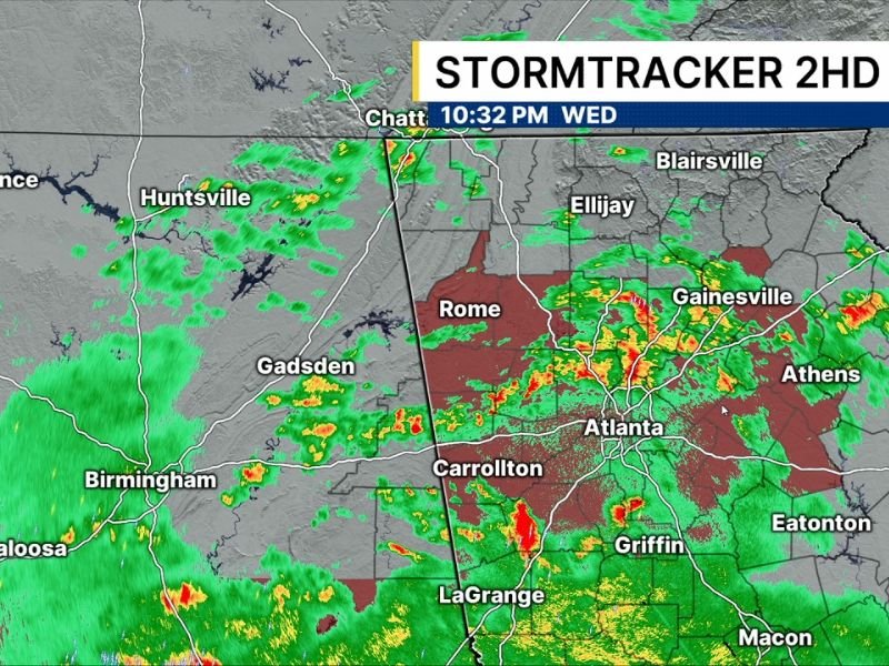
Despite the partial cancellation, the Tornado Watch remains firmly in place for metro Atlanta, where radar imagery from Stormtracker 2HD shows intense storm returns centered over and around the city as of 10:32 PM Wednesday. Areas including Rome, Gainesville, Carrollton, Griffin, and Athens all fall within the zone of active and developing storm activity, with the most aggressive radar returns clustered directly over the Atlanta metropolitan area.
Flooding Now the Primary Overnight Threat
As the tornado risk gradually transitions through the late night hours, forecasters warn that flooding is emerging as the dominant danger for metro Atlanta and surrounding communities. Between one and two inches of rainfall has already accumulated across many parts of the region, with an additional two inches considered likely in spots before the storm system moves through completely.
That cumulative rainfall total raises serious concerns about flash flooding in low-lying areas, roadways, and neighborhoods across the greater Atlanta region overnight.
Residents Advised to Monitor Conditions Closely
With additional storm development expected through the overnight hours and rainfall totals climbing, residents across metro Atlanta and surrounding counties are strongly urged to avoid unnecessary travel, stay away from flood-prone roadways, and keep emergency alert systems active until conditions fully improve.
For continuing coverage of severe weather events and critical storm analysis across the United States, visit SaludaStandard-Sentinel.com.