Developing Showers and Thunderstorms Rapidly Increasing Across South and Central Texas Thursday Night With Radar Filling In Toward San Antonio, Austin, Kerrville, and Del Rio
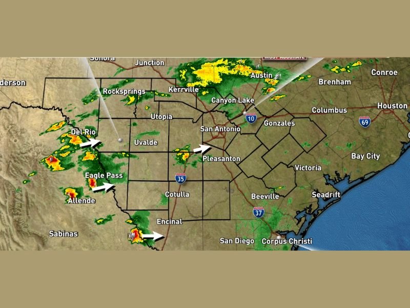
SAN ANTONIO, TX — Increasing atmospheric lift from an approaching upper level system was driving a rapid development of showers and thunderstorms across South and Central Texas at 9:30 PM Thursday, with Live Power Doppler radar captured at 9:25 PM showing active storm cells already pushing into the Del Rio, Eagle Pass, and Austin corridors as radar coverage was expected to fill in significantly through the overnight hours.
The developing storm system showed multiple active cells moving eastward across the region, with precipitation arrows on radar indicating storm motion pushing toward San Antonio, Pleasanton, and the broader South Texas corridor as the upper level system continued driving increasing lift across the atmosphere overnight.
Upper Level System Drives Rapid Storm Development
The approaching upper level system was identified as the primary forcing mechanism behind the rapidly developing shower and thunderstorm activity across South and Central Texas Thursday night. Increasing lift associated with the upper level disturbance was triggering convective development across the region, with storms gradually popping up across multiple areas simultaneously as the system pushed into the area from the west.
Radar was expected to fill in considerably through the hours ahead as the upper level system strengthened its influence across the South Texas atmosphere, bringing progressively more widespread and organized precipitation coverage across the affected region through the Thursday overnight period.
Active Cells Already Pushing Toward San Antonio Corridor
Live Power Doppler radar showed active and intensifying storm cells already developing across the Del Rio, Eagle Pass, Allende, and Kerrville corridors at 9:25 PM, with the storm motion arrows pointing eastward toward San Antonio, Pleasanton, Canyon Lake, and surrounding Central Texas communities.
Further north, precipitation was visible pushing through the Austin area and extending toward Kerrville and Junction, while southern cells near Encinal tracked northeastward toward the Cotulla and Pleasanton corridor. The multi-directional storm development across the region reflected the broad atmospheric response to the approaching upper level system Thursday night.
Radar Coverage Expected to Fill In Through the Night
With increasing lift continuing to push into the region from the approaching upper level disturbance, radar coverage across South and Central Texas was forecast to expand and intensify significantly through the overnight hours beyond the 9:25 PM snapshot. Communities across San Antonio, Austin, Kerrville, Uvalde, Gonzales, Victoria, and Corpus Christi were all positioned within the area of expected overnight precipitation expansion as the storm system matured.
Residents across the South and Central Texas corridor were advised to monitor updated radar through the overnight hours as conditions were expected to become increasingly active well into the Friday morning timeframe. For continuing coverage of weather events and critical storm analysis across the United States, visit SaludaStandard-Sentinel.com.