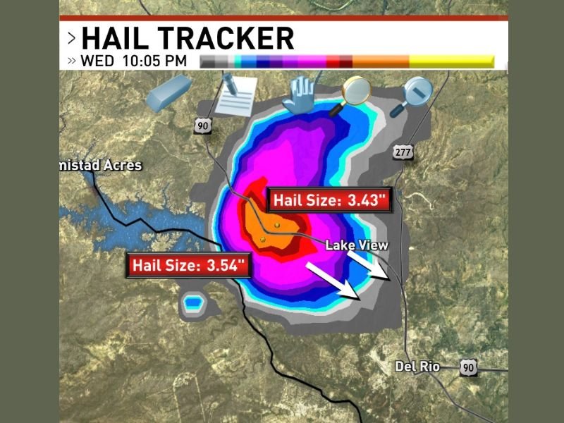
Giant 3.54 Inch Hail Producing Supercell Strikes Lake Amistad, Texas Heading Southeast Threatening Del Rio, Lake View, and Amistad Acres
DEL RIO, TX — A powerful supercell thunderstorm producing giant hail measuring up to 3.54 inches in diameter was tracked over Lake Amistad, Texas at 10:05 PM Wednesday, moving southeast and threatening communities including Del Rio, Lake View, and Amistad Acres with some of the largest and most destructive hail recorded during the ongoing severe weather outbreak across the region.
Hail Tracker data captured at 10:05 PM showed two distinct giant hail size readings within the supercell core, with measurements of 3.54 inches and 3.43 inches confirmed within the storm, placing this cell among the most destructive hail producers across the active severe weather pattern impacting southern Texas.
Giant Hail Core Centered Over Lake Amistad
The supercell’s most intense hail core was positioned directly over Lake Amistad at the time of the 10:05 PM observation, with the deep red and magenta hail tracker returns indicating the concentrated zone of largest hail within the storm’s updraft region. Hail measuring 3.54 and 3.43 inches in diameter falls well within the giant hail classification, representing stones capable of causing catastrophic damage to any exposed surface they contact.
Giant hail of this size punches through vehicle rooftops, shatters windshields, destroys residential and commercial roofing systems, and poses a direct and severe life-threatening risk to any individual caught outdoors during the storm’s passage.
Supercell Tracking Southeast Toward Del Rio Corridor
With the supercell moving southeast from its position over Lake Amistad, communities including Del Rio, Lake View, and Amistad Acres were positioned directly within the storm’s forward path at the time of the warning. The southeast track placed the full destructive hail core on a trajectory toward the Del Rio urban area, raising significant concern for property damage across one of the largest communities in the region.
The broad hail swath depicted on the Hail Tracker imagery showed the damaging hail field extending well beyond the immediate core zone, with smaller but still significant hail sizes covering a wide geographic area surrounding the supercell’s most intense precipitation region over Lake Amistad.
Second Supercell Adds to Growing Hail Damage Footprint
The Lake Amistad supercell was described as another hail-producing storm in the area, indicating that at least one prior supercell had already impacted the region with giant hail before the 10:05 PM storm developed over the lake. The back-to-back nature of giant hail producing supercells across the Del Rio and Lake Amistad corridor pointed to an extraordinarily active and destructive severe weather evening for communities across this stretch of southwest Texas.
For continuing coverage of severe weather events and critical storm analysis across the United States, visit SaludaStandard-Sentinel.com.