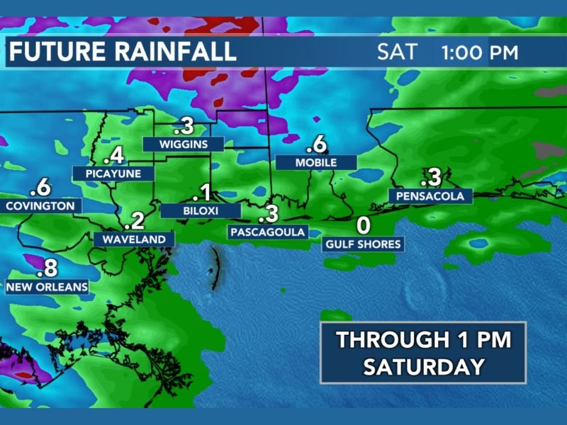
Storms Moving Through Louisiana, Mississippi and Alabama Friday Night Into Saturday Morning With New Orleans, Mobile and Covington Expected to See the Highest Rainfall Totals
GULF COAST — A tricky forecast setup is unfolding Friday night into Saturday morning across the Gulf Coast region, as storms developing to the north are expected to slide southward and attempt to hold together as they move through Louisiana, Mississippi, and Alabama. The WLOX First Alert future rainfall forecast valid through 1:00 PM Saturday shows measurable precipitation spread across a broad stretch of the region, though forecasters note that evening model trends are not optimistic about widespread heavy rainfall occurring across the entire area.
The overall message is that communities across the Gulf Coast will take whatever rainfall they can get from this system, even if totals fall short of earlier expectations.
New Orleans and Covington Lead Rainfall Totals
The highest projected rainfall totals through Saturday afternoon are concentrated across southeastern Louisiana and the immediate New Orleans metro area. New Orleans is forecast to receive approximately 0.8 inches through 1:00 PM Saturday, making it the highest total on the forecast map for this event.
Covington, located just north of Lake Pontchartrain, is projected to pick up around 0.6 inches, while Baton Rouge to the west is forecast to receive approximately 0.3 inches. The concentration of heavier rainfall across the New Orleans corridor reflects the southward sliding nature of the storm system as it tracks through the region overnight.
Mississippi Gulf Coast Sees Scattered Totals
Across the Mississippi Gulf Coast, rainfall totals are more scattered and variable depending on how well the storm system holds together as it slides southward. Picayune is forecast to receive around 0.4 inches, while Wiggins is projected near 0.3 inches. Waveland is expected to pick up approximately 0.2 inches, with Biloxi forecast near 0.1 inches.
Pascagoula is projected at approximately 0.3 inches, while Gulf Shores on the Alabama coast is currently forecast to receive little to no measurable rainfall through Saturday afternoon, sitting at zero on the current forecast map.
Alabama Coast and Florida Panhandle See Light Totals
Further east across the Alabama coast and into the Florida Panhandle, rainfall totals remain on the lighter end of the forecast spectrum. Mobile is projected to receive approximately 0.6 inches through Saturday afternoon, making it one of the higher totals on the eastern end of the forecast area. Pensacola is forecast to pick up around 0.3 inches as the storm system’s eastern fringe reaches into the Florida Panhandle.
Forecasters caution that these totals could shift depending on how well the storm system maintains its organization as it slides southward through the overnight hours into Saturday morning.
Are you tracking the incoming rainfall across Louisiana, Mississippi and Alabama this weekend? Share what conditions look like in your area and stay informed with the latest coverage at SaludaStandard-Sentinel.com.