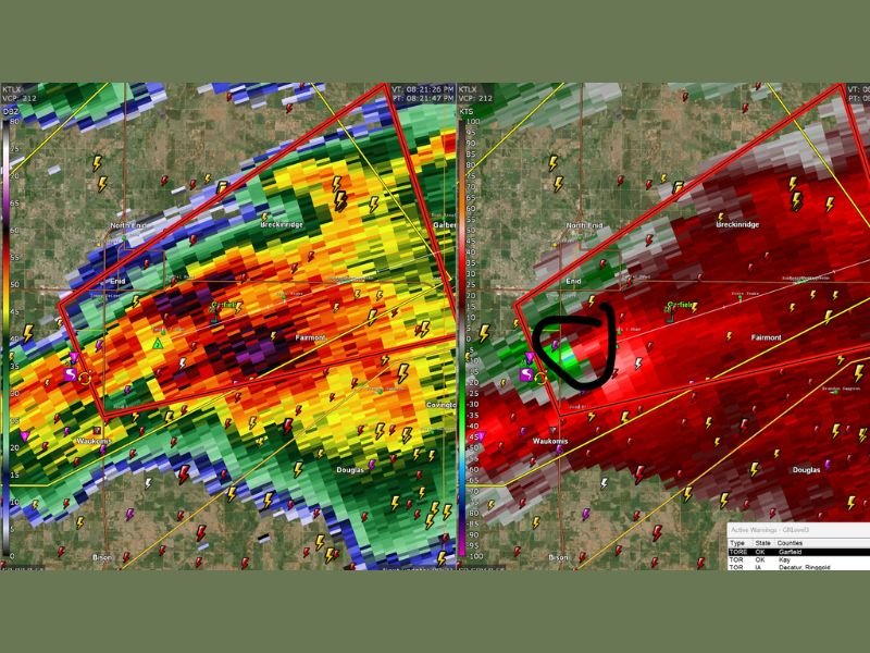
Large Tornado Emergency in Enid, Oklahoma as Debris Ball Detected on Radar Near Breckinridge With Violent Rotation Moving Toward Fairmont
ENID, OKLAHOMA — A tornado emergency has been declared as a powerful and dangerous tornado moves across areas near Enid, with radar imagery indicating a strong circulation and potential debris on the ground.
The situation rapidly intensified as storm trackers identified a well-defined rotation approaching Breckinridge and Fairmont, prompting urgent warnings for residents to take shelter immediately.
Tornado Emergency Declared as Violent Storm Moves Through Enid Area
Meteorological data shows a highly organized storm system producing extreme rotational signatures. The warning area highlighted in red indicates the tornado’s projected path, stretching across populated zones just north and east of Enid.
The designation of a “tornado emergency” signals a life-threatening situation, typically reserved for confirmed large and destructive tornadoes. This suggests the storm is not only present but potentially causing damage on the ground. Emergency officials have urged residents to seek shelter in interior rooms, basements, or storm shelters as conditions remain extremely dangerous.
Radar Imagery Shows Debris Signature Near Breckinridge
Advanced radar scans reveal a concerning feature often associated with strong tornadoes — a debris ball. This appears as a tight area of intense reflectivity, indicating that the storm may be lifting objects such as trees, vehicles, or structures into the air.
The highlighted region near Breckinridge shows a clear correlation between strong velocity rotation and high reflectivity, reinforcing the likelihood of a damaging tornado actively impacting the area.
Frequent lightning strikes and intense precipitation further complicate visibility, making it difficult for residents to visually confirm the tornado’s position.
Storm Path Extends Toward Fairmont and Surrounding Areas
The storm’s trajectory suggests continued movement toward communities east of Enid, including Fairmont. Radar velocity data shows strong inbound and outbound winds tightly packed together — a classic signature of a rotating mesocyclone.
As the storm progresses, the risk of additional tornado development or strengthening cannot be ruled out. Weather conditions remain volatile, with the potential for rapid changes in storm intensity. Residents in the projected path are being advised to stay alert to local alerts and avoid travel under any circumstances.
Emergency Warnings Emphasize Immediate Shelter
Authorities continue to stress the urgency of the situation. Tornado emergencies are rare and indicate imminent danger to life and property.
People in affected areas should move to the lowest level of their homes, avoid windows, and protect themselves with heavy furniture or mattresses if possible. Mobile homes and vehicles are especially vulnerable and should be abandoned for sturdier shelter if time allows.
First responders are preparing for potential damage reports, though conditions remain too dangerous in some areas for immediate assessment. As this situation develops, more updates are expected regarding damage, injuries, and the storm’s continuing path.
If you are in the Enid area or nearby communities, share what you’re seeing and how conditions are unfolding. Stay with SaludaStandard-Sentinel.com for real-time updates and critical safety information as this dangerous tornado event continues.