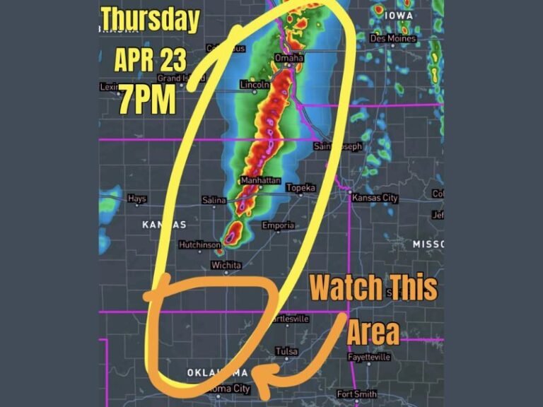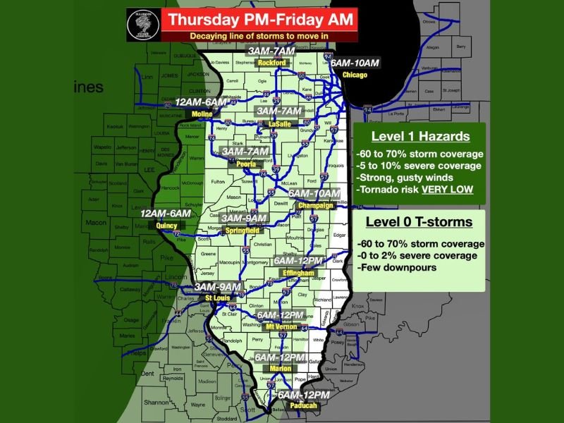
Decaying Line of Thunderstorms to Move Across Illinois, Missouri and Iowa Thursday Night Into Friday Morning With 60 to 70 Percent Storm Coverage and Very Low Tornado Risk
ILLINOIS — A line of thunderstorms developing across the Plains is expected to race into Iowa and Missouri Thursday afternoon before pushing through Illinois Thursday night into Friday morning. Forecasters describe the overall concern level as low, noting that while general rain coverage will be widespread at 60 to 70 percent, severe weather coverage remains very limited at just 2 to 10 percent across the affected region.
As the storm line moves eastward toward Illinois, it is expected to outrun the better instability and lose daytime heating, placing the storms in a decaying state. By the time the line reaches the Mississippi River around midnight, it will have weakened considerably, though an isolated strong wind gust remains possible in some areas.
Timing and Arrival Windows Across the Region
The timing of storm arrival varies significantly depending on location across the affected area. Rockford and Moline are expected to see storms arrive between 3 AM and 7 AM, while Chicago is forecast to receive storm activity between 6 AM and 10 AM Friday. Peoria is in the 3 AM to 7 AM window, with Champaign following between 6 AM and 10 AM.
Further south and west, Quincy and St. Louis are forecast to see storms between 3 AM and 9 AM, with Springfield in the 3 AM to 9 AM range as well. Effingham, Mt. Vernon, Marion, and Paducah are all expected to see activity between 6 AM and 12 PM Friday, with the storm line progressively weakening as it tracks southeast through the region.
Hazard Levels Across the Storm Zone
Forecasters have issued two distinct hazard classifications for areas within the storm corridor. Areas falling under the Level 1 Hazard designation, including portions of central and northern Illinois, face 60 to 70 percent storm coverage, 5 to 10 percent severe coverage, strong gusty winds, and a very low tornado risk. Areas under the Level 0 designation can expect 60 to 70 percent storm coverage, 0 to 2 percent severe coverage, and a few downpours with no meaningful severe weather concern.
Tornado risk across the entire region is described as very very low and not a concern by forecasters, providing some reassurance for residents in the path of the storm line.
What Residents Should Expect Thursday Night Into Friday
Most residents across Illinois, Missouri, and surrounding areas will primarily experience rain from this system rather than any significant severe weather. Forecasters note that intensity for this event rates just 1 out of 10, meaning impacts are expected to remain minimal for the vast majority of communities in the storm path.
Drivers heading out during the overnight and early morning hours should be aware of wet road conditions and reduced visibility during periods of heavier rain. Those in the Level 1 hazard zone should remain alert for any isolated strong wind gusts that could accompany the stronger cells within the line.
Are you tracking the incoming storm line across Illinois and Missouri this Thursday night? Share what conditions look like in your area and stay informed with the latest weather coverage at SaludaStandard-Sentinel.com.