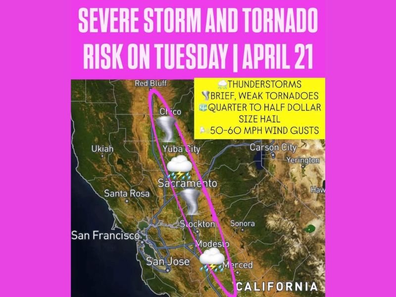
Weak Tornadoes, Large Hail and 60 MPH Wind Gusts on the Way for California’s Sacramento and San Joaquin Valleys as Strong Storm System Moves In Tuesday
SACRAMENTO, CALIFORNIA — A strong storm system approaching the California coast is bringing a round of severe thunderstorm and tornado chances to the Sacramento Valley and parts of the San Joaquin Valley on Tuesday, April 21, 2026. Forecasters are warning residents to remain weather aware throughout the late morning, afternoon, and evening hours as conditions are favorable for a couple of strong to severe thunderstorms capable of producing brief weak tornadoes, large hail, and damaging wind gusts across a wide corridor of Central California.
The threat area stretches from Red Bluff and Chico in the north through Sacramento, Stockton, Modesto, and Merced in the south, covering one of the most densely populated inland regions of the state.
Severe Weather Threats Across the Sacramento Valley
The Sacramento Valley is facing the most concentrated severe weather risk Tuesday. Areas including Red Bluff, Chico, Yuba City, and Sacramento are all within the primary threat corridor where forecasters say brief weak tornadoes or funnel clouds are possible. Quarter to half dollar size hail is also forecast for parts of this region, along with wind gusts reaching 50 to 60 mph capable of downing trees and causing localized property damage.
Residents in and around Sacramento are urged to stay weather aware throughout the day and move indoors immediately if thunderstorms develop nearby.
San Joaquin Valley Also Under Threat Tuesday
The severe weather risk extends southward into the San Joaquin Valley, where Stockton, Modesto, and Merced are all in the path of potential storm activity. Thunderstorms tracking through this corridor could bring similar hazards including damaging winds, hail, and brief tornado or funnel cloud activity. The combination of the approaching coastal system and favorable atmospheric instability over the valley floor is supporting the elevated severe weather potential throughout the afternoon and evening.
Safety Guidance for Residents in the Threat Zone
Forecasters are advising all residents within the affected corridor to monitor local weather alerts closely and have a safety plan in place before storms arrive. If a severe thunderstorm warning or tornado warning is issued for your area, seek shelter immediately in an interior room on the lowest floor of a sturdy building. Avoid travel during active storm periods and stay away from windows, flooded roadways, and open areas where lightning and wind pose serious risks.
Are you tracking the severe weather threat across California’s Central Valley today? Share what conditions look like in your area and stay informed with the latest coverage at SaludaStandard-Sentinel.com.