Nationwide Cold Front Pushes Freezing Temperatures and Frost Risk Across Northern States Through Florida by April 20 This Weekend
UNITED STATES — Winter is not finished with the country just yet. A significant cold front is forecast to push southward this weekend, dragging freezing temperatures and frost conditions back into northern states by Sunday and Monday, April 19 and 20, while simultaneously driving temperatures down into the 50s as far south as Florida. The dramatic late-season cold snap will affect a broad swath of the nation, reminding residents that spring warmth remains vulnerable to powerful Arctic intrusions well into April.
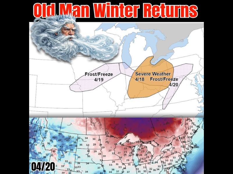
Forecast graphics outlined a multi-day weather threat sequence beginning with a severe weather event on April 18 across the central United States, followed by widespread frost and freeze conditions spreading across northern and central regions through April 19 and 20 as the cold front pushes progressively further south.
Severe Weather Threat Ahead of the Front on April 18
Before the cold air arrives, the clash between warm and cold air masses will first generate a severe weather threat across portions of the central United States on Saturday, April 18. Forecast guidance showed a significant severe weather risk zone positioned across the Midwest and Great Plains as the advancing cold front collides with warm, unstable air ahead of it.
Residents in the severe weather risk zone should begin monitoring forecasts closely heading into the weekend, as damaging winds, large hail, and tornadoes are all possible ahead of the frontal boundary before temperatures crash behind it.
Frost and Freeze Conditions Spreading Across the North
As the cold front pushes through, frost and freeze conditions are expected to develop across northern states by Sunday, April 19, with the freeze threat expanding further south and east by Monday, April 20. Temperature forecast maps valid for April 20 showed widespread readings in the 20s and 30s across the northern Plains, Great Lakes region, and portions of the Northeast, with temperatures only gradually moderating further south.
The timing of this late-season freeze is particularly concerning for agricultural interests and home gardeners across the affected regions, as many areas have already seen significant vegetation growth and blooming triggered by the recent stretch of warm spring temperatures. A hard freeze at this stage of the growing season can cause significant damage to crops, fruit trees, and ornamental plantings across a wide area.
Florida Not Spared as 50s Push Deep Into the Sunshine State
Even Florida will feel the punch of this cold front, with temperatures expected to drop into the 50s across portions of the state by the time the system reaches its southernmost extent. While not a freeze threat for the Sunshine State, temperatures in the 50s represent a dramatic departure from the warm conditions Floridians have been enjoying and will serve as a reminder that late April cold fronts can still deliver notable chilly spells even in the nation’s warmest state.
Residents across all affected regions should prepare for the temperature swing by protecting sensitive plants, ensuring heating systems are operational, and having warm clothing readily accessible as the cold front arrives this weekend.
Are you preparing for the return of cold temperatures and frost risk this weekend? Share your plans and stay connected with the latest forecast updates at SaludaStandard-Sentinel.com.