Midwest Severe Weather Breaks Thursday as Sunny Skies and Warm Temperatures Return With Fresh Storm Threat Possible Friday
MIDWEST — After several days of relentless and historic severe weather activity, residents across the Midwest are finally getting a well-earned break on Thursday, April 16, 2026, as severe weather pushes out of the region and gives way to pleasantly warm temperatures and increasingly sunny skies through the afternoon and evening hours. A stray shower or storm may linger through mid-morning, but the bulk of the day is expected to be dry and enjoyable.
Forecasters described the break as a much-needed opportunity to exhale following one of the busiest and most intense stretches of severe weather seen in recent memory, while also cautioning that renewed severe weather prospects are already on the radar for Friday and should be monitored closely as the day progresses.
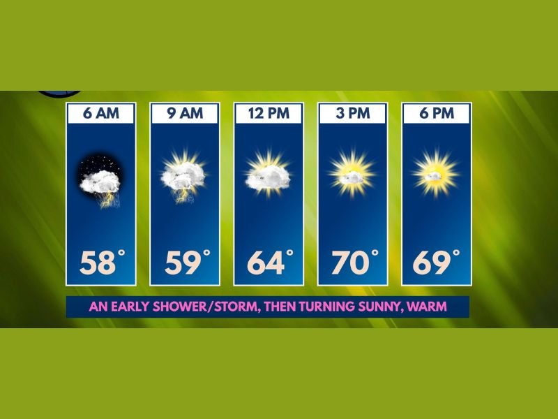
Hour by Hour Forecast for Thursday
Hourly forecast data showed a clear and steady improvement in conditions throughout Thursday. Early morning hours at 6 AM started with lingering clouds and a stray shower or storm possibility at 58 degrees, with conditions beginning to improve by 9 AM as temperatures edged up to 59 degrees and storm chances diminished.
By noon, partly cloudy skies were expected with temperatures reaching 64 degrees, followed by a pleasant afternoon warm-up to 70 degrees by 3 PM under mostly sunny skies. The evening hours at 6 PM will remain warm and comfortable at 69 degrees with continued sunshine, making for an ideal evening to spend time outdoors after days of severe weather confinement.
Severe Weather Behind Us for Now
Forecasters confirmed that the prolonged and dangerous severe weather outbreak that battered portions of the Midwest over the past several days has finally pushed out of the region, at least temporarily. The back-to-back rounds of severe storms, tornadoes, damaging winds, and flash flooding that impacted communities across multiple states appear to have concluded for the immediate short term.
Residents who experienced storm damage over the past several days are encouraged to use Thursday’s calm conditions to safely assess and document any property damage, clear debris from roadways and yards, and check on neighbors and community members who may have been impacted by the severe weather outbreak.
Friday Severe Weather Threat Being Monitored
While Thursday offers a welcome respite, forecasters are already keeping a close eye on renewed severe weather prospects for Friday. The atmospheric pattern that fueled this week’s outbreak has not fully departed, and conditions could become favorable once again for storm development as early as Friday.
Residents across the Midwest should enjoy Thursday’s calm but remain weather-aware heading into the end of the week. Checking back with local forecasters later Thursday for updated assessments of Friday’s severe weather potential is strongly recommended, as the threat timing and coverage area will become clearer as computer models refine their guidance throughout the day.
Are you enjoying the much-needed break from severe weather across the Midwest today? Share your thoughts and stay prepared with the latest forecasts at SaludaStandard-Sentinel.com.