Michigan Lone Thunderstorm Crossing Lake Michigan Toward Allegan County Bringing Lightning and Isolated Hail Risk Wednesday Which Has Had a History of Hail in Wisconsin And Illinois
WESTERN MICHIGAN — A lone thunderstorm carrying a history of hail production across Wisconsin and Illinois was tracking eastward over Lake Michigan toward Allegan County at 5:23 AM Eastern Time Wednesday, April 15, 2026, with forecasters noting that frequent cloud-to-ground lightning represents the primary hazard as the storm makes its approach toward the western Michigan shoreline.
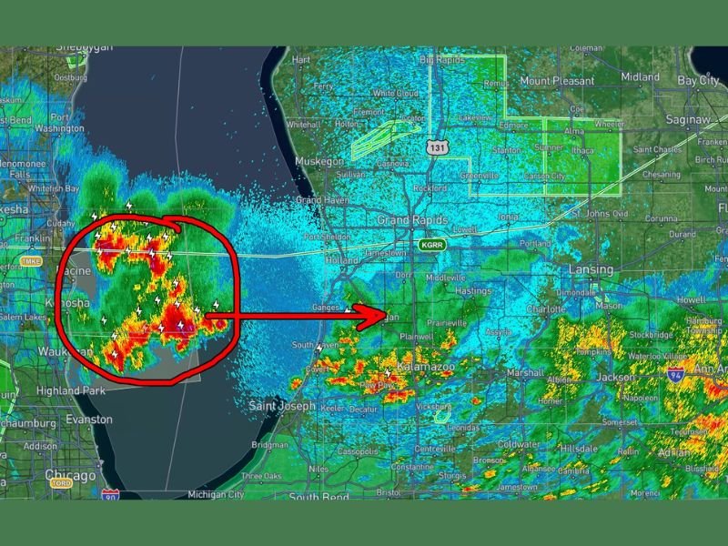
Radar imagery clearly showed the storm system circled over Lake Michigan with a distinct eastward track pointing directly toward the Grand Haven, Holland, and Allegan County areas, with the storm’s movement confirmed by meteorologists actively monitoring its progression across the lake.
Storm History and Current Threat Level
The storm originated over Wisconsin and Illinois, where it had already demonstrated a history of producing hail before moving over Lake Michigan toward Michigan’s western shore. While the cell is currently producing frequent cloud-to-ground lightning as its main hazard, isolated small hail cannot be ruled out as the storm continues its eastward journey and approaches land.
Forecasters were cautious in their assessment, noting that it remains unclear how long the storm will maintain its current structure as it crosses the lake. At the time of the update, forecasters did not anticipate the storm becoming severe, though active monitoring was confirmed to be ongoing given its hail-producing history.
Areas in the Storm’s Projected Path
Based on the radar track visible at the time of the 5:23 AM update, communities along western Michigan’s Lake Michigan shoreline and inland areas of Allegan County were in the most direct path of the approaching storm. Areas including South Haven, Holland, Grand Haven, and surrounding communities in Allegan and Ottawa counties were positioned along the storm’s projected track as it moved onshore from the lake.
Residents in these communities should anticipate a period of frequent lightning activity as the storm moves through, along with the possibility of isolated small hail depending on how the cell evolves once it reaches land and interacts with the changing atmospheric environment over western Michigan.
Lightning Safety as the Primary Concern
With frequent cloud-to-ground lightning identified as the main hazard from this storm, residents and early morning commuters in western Michigan should take the threat seriously even though the storm is not expected to reach severe levels. Lightning is one of the most dangerous and unpredictable aspects of any thunderstorm, capable of striking several miles away from the heaviest rainfall.
Anyone outdoors in the storm’s path should seek shelter inside a sturdy building or hard-topped vehicle immediately upon hearing thunder or seeing lightning. Avoid open fields, tall trees, bodies of water, and elevated areas until the storm has fully passed and at least 30 minutes have elapsed since the last observed lightning strike.
Are you tracking Wednesday morning’s storm activity along Michigan’s western shoreline? Share your observations and stay connected with our weather coverage at SaludaStandard-Sentinel.com.