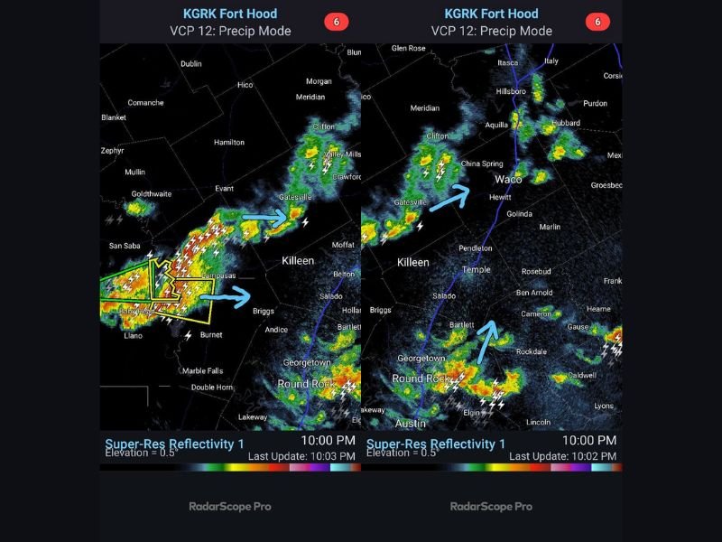
Severe Thunderstorm Pushes Into Burnet and Lampasas Counties Texas Bringing Large Hail, Flash Flooding Risk and Lightning Toward Killeen and Fort Hood Before Midnight
TEXAS — A severe thunderstorm is actively pushing east into northern Burnet County and impacting areas south of Lampasas as of the 10 PM Sunday radar update, bringing large hail, frequent lightning, and heavy downpours capable of producing flash flooding across the affected corridor. The storm has been building north into Lampasas County and is expected to shift east into Cove, Killeen, and Fort Hood before midnight, putting these communities directly in the path of dangerous weather during the late night hours.
Severe Storm Targeting Lampasas and Burnet County With Large Hail
The primary severe thunderstorm is currently concentrated in the northern Burnet County and southern Lampasas area, with radar showing intense returns and frequent lightning strikes firing within and around the storm’s core. Large hail is the primary severe weather hazard with this storm, capable of causing significant damage to vehicles, property, and injuring anyone caught outdoors.
Heavy downpours accompanying this storm are also raising flash flooding concerns for areas along and south of Lampasas. Residents in low-lying areas near creeks and drainage systems in Burnet and Lampasas Counties should monitor conditions closely and be prepared to move to higher ground if flooding develops rapidly overnight.
Storm Shifting East Toward Cove, Killeen and Fort Hood Before Midnight
The severe thunderstorm is not staying stationary. It is actively tracking east and will impact Cove, Killeen, and Fort Hood before midnight Sunday night. Residents and personnel in these communities have a limited window to prepare before this storm arrives with large hail, frequent lightning, and heavy rainfall.
Anyone outdoors in the Killeen and Fort Hood area should move inside immediately and remain sheltered until the storm passes through the region. Do not drive through any areas where water is covering roadways as flash flooding conditions can develop rapidly with the heavy rainfall accompanying this system.
Scattered Storms Also Developing South Toward Austin and Temple
Elsewhere across Central Texas, scattered storms have developed south toward Austin and are lifting north toward Temple, Cameron, and areas east of the Interstate 35 corridor. These additional storms are not expected to reach severe thresholds but are capable of producing small hail, gusty winds, and frequent lightning across the affected communities including Waco, Gatesville, Salado, Georgetown, and Round Rock.
The overall atmospheric energy across Central Texas remains sufficient to keep storm activity alive through the overnight hours, and the risk of localized flooding will continue to increase as rainfall accumulates across already wet ground. Stay off flooded roads and follow updates at SaludaStandard-Sentinel.com.