Tornado Touches Down East of Chester Nebraska at 5:04 PM as Powerful Supercell Fires Along Warm Front in Highly Conditional Setup
NEBRASKA — A tornado touched down east of Chester, Nebraska at approximately 5:04 PM, as a highly conditional severe weather setup produced a powerful supercell structure that fired along a warm front during the afternoon hours. The storm developed in an environment where initiation was far from certain, making the eventual tornado all the more significant for communities across the region.
Conditional Setup Fires Against the Odds
The severe weather risk on this day was described as highly conditional, meaning storm development depended entirely on whether convection could fire along the warm front. Despite the uncertainty surrounding the setup, storms did initiate and rapidly organized into a top tier supercell capable of producing a tornado across the rural Nebraska landscape.
The resulting storm featured dramatic rotating structure and a well-defined wall cloud as it matured during the late afternoon hours east of Chester. The development validated concerns that even conditional setups demand full attention from residents in potentially affected areas.
Tornado Confirmed East of Chester at 5:04 PM
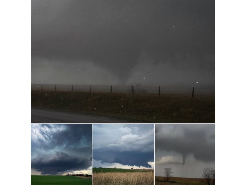
The tornado was confirmed east of Chester, Nebraska at around 5:04 PM, with photographs showing a well-defined funnel extending toward the ground against a dark and turbulent sky. The images captured during the event show the supercell from multiple angles, including a clearly rotating base and a developing funnel visible descending near a line of bare trees across open farmland.
The tornado formed quickly as the supercell reached peak intensity, underscoring how rapidly conditions can deteriorate during warm front severe weather events across the Plains states.
Storm Structure Showed Classic Supercell Characteristics
Photographs from the event reveal a well-organized and dangerous supercell throughout its lifecycle. Images show a classic rotating supercell base with striated structure indicating a strongly organized storm, a broad and low-hanging base stretching over open Nebraska farmland, and a clearly defined funnel descending toward the surface.
Together these images represent a textbook warm front tornado-producing supercell, the kind of storm that can develop quickly and strike with little warning in areas where the overall regional threat level appears relatively low on outlook maps.
A Reminder That Conditional Setups Still Demand Caution
Residents across Nebraska and the broader Plains region are reminded that warm front tornado events can unfold rapidly and in locations where storm chances appear marginal on regional forecasts. A conditional setup does not mean a safe setup, and staying weather-aware during any active severe weather day remains critical regardless of the overall risk category assigned to your area.
Have you witnessed severe weather in your area recently? Share your reports at SaludaStandard-Sentinel.com.