Central and Southern Plains Including Texas Oklahoma and Kansas Show Rising Supercell Storm Potential Over Next Two to Three Weeks
UNITED STATES — New long-range forecast data is highlighting an increasing potential for severe thunderstorm development across the central and southern Plains, particularly in states like Texas, Oklahoma, and Kansas over the next two to three weeks.
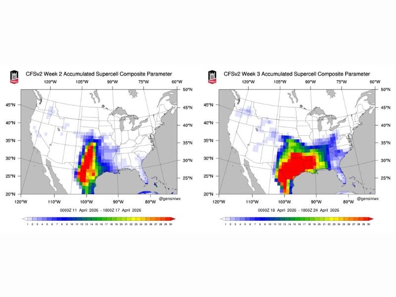
The outlook is based on the Accumulated Supercell Composite Parameter, a forecasting tool designed to identify areas where atmospheric conditions may support rotating thunderstorms capable of producing severe weather.
Forecast Tool Signals Favorable Conditions for Rotating Storms
The Accumulated Supercell Composite Parameter combines several key atmospheric ingredients—including instability, wind shear, and helicity—to assess the potential for organized, rotating storms.
When these factors align over time, they create an environment more favorable for supercells, which are often associated with severe weather hazards such as large hail, damaging winds, and tornadoes.
Highest Signals Emerging Across Texas Oklahoma and Kansas
Forecast maps for the coming weeks show the most concentrated areas of concern centered over portions of Texas, Oklahoma, and Kansas. These regions are beginning to show stronger signals, indicating a higher likelihood of severe weather setups developing.
The intensity of the colors on the map suggests that these areas could see more frequent or more organized storm activity compared to surrounding regions.
Expanding Risk Into Surrounding States Possible
As the pattern evolves, neighboring areas across the southern Plains and parts of the central United States may also see an increase in storm potential.
While the exact locations and timing of individual storms cannot be determined this far in advance, the broader pattern suggests an active period for severe weather as spring progresses.
Long Range Outlook Provides Early Warning but Not Certainty
It is important to note that this type of long-range forecasting highlights potential rather than guaranteed outcomes. While the data suggests a favorable environment for severe storms, actual storm development will depend on more immediate weather conditions.
Still, tools like this provide valuable early insight into periods when severe weather risk may increase.
Spring Transition Bringing More Active Weather Pattern
The developing pattern aligns with the typical spring transition across the Plains, when warm, moist air from the Gulf of Mexico interacts with cooler air masses to create unstable conditions.
This seasonal shift often leads to an uptick in thunderstorm activity, particularly in regions known for severe weather outbreaks.
Residents Encouraged to Stay Weather Aware in Coming Weeks
With signals pointing toward a more active period ahead, residents across the central and southern Plains are encouraged to stay informed and prepared as the season progresses.
Even though the forecast is long-range, it serves as an early reminder of the potential for severe weather in the weeks ahead.
If you’re located in one of the highlighted regions and want to share what you’re seeing or preparing for, connect with us at SaludaStandard-Sentinel.com and help keep your community informed.