Rogers, Washington and Nowata Counties in Oklahoma Under Severe Thunderstorm Warning as Intense Storm Line Pushes Through With Lightning and Wind Threat
OKLAHOMA — A severe thunderstorm warning was issued Friday evening for northwestern Rogers County, southern Washington County, and southern Nowata County as a strong line of storms pushed across northeastern Oklahoma.
The warning, in effect until 9:15 PM, covered multiple communities in the path of an intensifying storm system producing heavy rain, lightning, and the potential for damaging winds.
Strong Storm Line Moves Through Northeastern Oklahoma
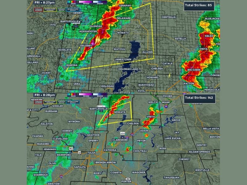
Radar imagery shows a well-defined line of storms stretching from areas near Bartlesville down toward Nowata and extending into regions near Claremore and Vinita. The system is moving steadily, bringing bursts of intense rainfall and frequent lightning strikes.
The most active portion of the storm appeared along a narrow but powerful band, indicating a risk for sudden changes in weather conditions as it passes through each location.
Lightning Activity and Heavy Rainfall Intensify the Threat
Data from the radar indicated a high number of lightning strikes within the storm system, signaling strong updrafts and active thunderstorm development. This type of setup often leads to brief but intense downpours and reduced visibility.
Communities within Rogers, Washington, and Nowata counties experienced rapidly changing conditions, with storms strengthening as they tracked eastward across the region.
Localized Wind Damage Risk Remains a Concern
Although the primary threat focused on heavy rain and lightning, strong wind gusts remained a key concern during the warning period. These gusts could potentially lead to minor damage, including downed tree limbs or isolated power disruptions.
The narrow structure of the storm line suggests that impacts may vary significantly from one area to another, with some locations seeing stronger bursts of wind than others.
Storms Continue to Push East as Warning Timeline Progresses
As the evening progressed, the storm line continued moving eastward, gradually shifting the threat toward additional communities beyond the warned counties. Areas further east of Nowata and Rogers counties were expected to monitor conditions closely as the system advanced.
While the warning remained active during the timeframe, conditions were expected to evolve quickly, requiring residents to stay alert for any updates or additional alerts.
Residents Urged to Stay Weather Aware
Officials urged residents in the warned areas to remain cautious and prepared as storms moved through. Staying indoors, avoiding travel during heavy rainfall, and monitoring alerts were key recommendations during the warning period.
Even as storms move out, lingering rain and wet roads may continue to create minor hazards across the region. If you experienced severe weather in your area, share your updates with us at SaludaStandard-Sentinel.com and help keep your community informed.