New Hampshire, Vermont, Maine and Massachusetts Face 20 to 30 Degree Temperature Swings With Rain, Snow and Icing Risks Through Midweek
NEW ENGLAND — A complex and rapidly changing weather pattern is set to bring dramatic temperature swings and mixed precipitation across parts of New Hampshire, Vermont, Maine, and Massachusetts through midweek.
Forecasters warn that some areas could see temperature differences of 20 to 30 degrees within short distances, along with shifting conditions between rain, snow, and potential icing.
Unusual Temperature Swings Create Sharp Differences Across Short Distances
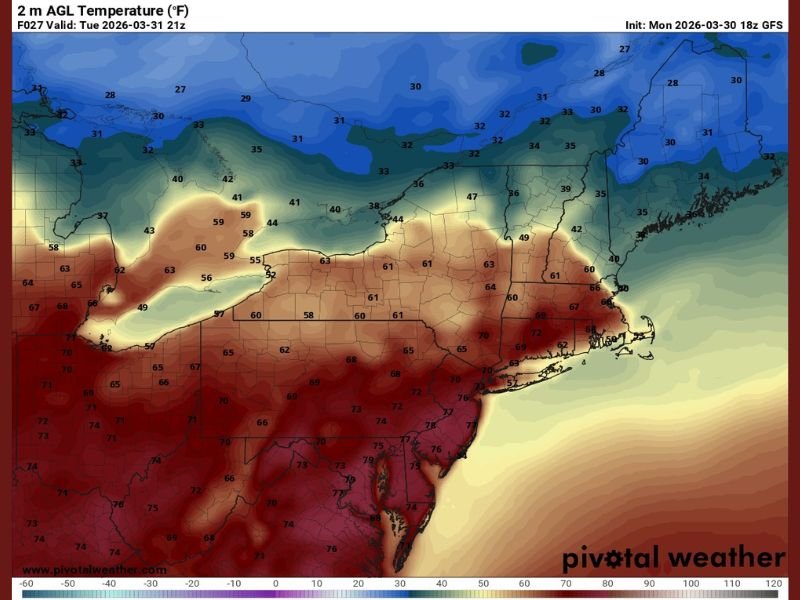
One of the most notable aspects of this setup is how temperatures will behave differently across the region at the same time.
In southern New England, temperatures will follow a more typical pattern with cooler mornings and warmer afternoons. However, northern areas will experience the opposite, with warmer conditions early in the day followed by steady cooling.
This setup could lead to extreme contrasts, such as temperatures near the mid-60s in parts of southern New Hampshire while areas just miles away drop into the upper 30s.
Tuesday Brings Rain South and Wintry Mix North
Rain is expected to dominate much of southern New England on Tuesday, extending northward into parts of New Hampshire and Vermont.
Further north, especially across Maine, conditions may support a wintry mix and periods of snow. A midday lull in precipitation is possible before steadier and heavier precipitation develops into the evening hours.
Wednesday Pattern Flips With Changing Rain and Snow Zones
By Wednesday, the weather pattern will shift again, with showers continuing across the region. Rain is expected across southern areas, while northern locations will continue to see snow or mixed precipitation.
Some breaks of sunshine may develop during the day, particularly south of the Massachusetts and New Hampshire border, before conditions reverse again later in the afternoon.
Thursday Brings Renewed Mixed Precipitation and Icing Risk
Another round of mixed precipitation is expected on Thursday, including sleet, freezing rain, and snow across much of New Hampshire, Vermont, and Maine.
Northern Maine is most likely to see accumulating snow, while other areas could face icing concerns depending on temperature profiles. This setup raises the potential for hazardous travel conditions, especially in areas where freezing rain develops.
Winds and Continued Temperature Fluctuations Add to Impacts
Light to moderate wind gusts are expected to continue into Wednesday, adding another layer of variability to the weather pattern. Temperatures will remain inconsistent, especially in southern New England where conditions may start warmer and cool throughout the day.
These rapid changes highlight the complexity of the system and the importance of staying updated as conditions evolve. Stay informed and share your local conditions or experiences by visiting SaludaStandard-Sentinel.com.