Loveland, Fort Collins and Windsor Colorado Hit by Intense Thunderstorm With Lightning and Heavy Rain Moving Across I-25 Corridor
LOVELAND, COLORADO — A strong thunderstorm moved across northern Colorado Friday evening, bringing bursts of heavy rain, frequent lightning, and loud thunder across the Loveland area and surrounding communities.
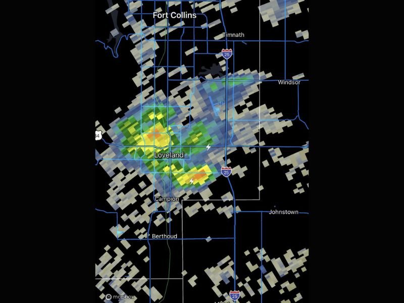
Radar imagery shows a concentrated storm cell centered near Loveland, with activity extending toward Fort Collins, Windsor, and along the Interstate 25 corridor.
Storm Cell Intensifies Over Loveland Area
The radar indicates a well-defined thunderstorm core directly over Loveland, with areas of heavier precipitation highlighted in yellow and orange. These colors typically represent stronger rainfall rates and potentially more intense storm activity.
Lightning strikes have been detected within the storm, confirming active thunderstorm conditions. Residents in the area have reported loud thunder as the system moves through. The storm appears compact but intense, capable of producing brief periods of heavy rain in localized areas.
Lightning and Thunder Impact Nearby Communities
Communities including Fort Collins, Windsor, and Campion are all within the storm’s path, with the system extending outward from Loveland.
Frequent lightning within the storm increases the risk of brief power interruptions and poses a safety hazard for anyone outdoors. Thunderstorms of this nature can also produce sudden downpours that reduce visibility for drivers. The proximity of the storm to major roadways, including I-25, may create challenging driving conditions during peak intensity.
Storm Moving Across I-25 Corridor
The positioning of the storm suggests it is tracking along or near the I-25 corridor, impacting one of the region’s most heavily traveled routes.
Drivers traveling between Fort Collins and Denver may encounter sudden weather changes, including heavy rain and lightning. As the storm continues to move, conditions could shift quickly, with areas experiencing brief but intense impacts before the system passes.
Short-Lived but Intense Weather Event
While the storm is not expected to last for an extended period, its intensity means it can still produce significant impacts in a short amount of time.
Localized rainfall totals could add up quickly under the strongest parts of the storm, and lightning activity may remain elevated until the system weakens. These types of storms are common during transitional weather patterns and can develop rapidly.
Conditions Expected to Improve After Passage
As the thunderstorm moves out of the area, conditions are expected to gradually improve, with rain tapering off and skies beginning to clear.
However, lingering moisture and cooler air may remain behind the storm, keeping conditions unsettled for a short period. Residents are encouraged to stay alert for additional storm development as weather patterns remain active.
Have you experienced the storm in Loveland or nearby areas tonight? Share your observations and stay updated with the latest weather alerts at SaludaStandard-Sentinel.com.