Southeast States Including Georgia, South Carolina, North Carolina, Alabama and Mississippi Set for Wetter Pattern as Bermuda High Builds Early
UNITED STATES — A significant shift in weather patterns is expected across the Southeast as the Bermuda High begins to establish itself earlier than usual, bringing increased moisture and rain chances heading into the Easter weekend.
This setup, typically seen later in May or June, is now showing signs of developing much sooner, signaling a notable change in atmospheric conditions across the region.
Bermuda High Begins Early Setup Over Atlantic
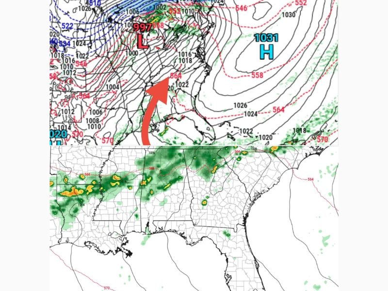
Weather models indicate a strengthening high-pressure system over the western Atlantic, commonly known as the Bermuda High. This system plays a key role in directing moisture into the southeastern United States during the warmer months.
Its earlier-than-normal development is drawing attention, as it suggests a transition toward a more humid and active weather pattern sooner than expected.
The positioning of this high-pressure system will influence how moisture flows inland over the coming days.
Tropical Moisture Pushed Into Southeast States
As the Bermuda High builds, it is expected to funnel tropical moisture into states including Georgia, South Carolina, North Carolina, Alabama, and Mississippi.
This influx of moisture will increase the likelihood of showers and thunderstorms, particularly as disturbances move through the region. The pattern resembles a conveyor belt of moisture feeding into the Southeast, supporting repeated chances for rainfall.
Rain Chances Increase Heading Into Easter Weekend
Forecast models show that this wetter pattern may begin taking shape as early as Easter weekend, with scattered showers and thunderstorms becoming more common across the region.
Rain coverage is expected to expand gradually, with some areas seeing multiple rounds of precipitation. While not every location will experience heavy rainfall at once, the overall trend points toward a more unsettled and active setup.
Pattern Change Marks Shift Toward Summer-Like Conditions
The arrival of the Bermuda High typically signals a move toward more summer-like weather across the Southeast, characterized by higher humidity and frequent storm chances.
This early transition could mean an extended period of active weather, especially if the pattern holds into the following weeks. The combination of moisture and warming temperatures creates favorable conditions for ongoing storm development.
Monitoring Needed as Pattern Continues to Evolve
While confidence is growing in the overall pattern shift, details such as exact timing and storm intensity remain uncertain.
Meteorologists will continue to monitor how the Bermuda High interacts with incoming systems and how moisture spreads across the region. Residents across the Southeast should stay aware of changing conditions as this early-season pattern begins to take hold.
If you’re in Georgia, South Carolina, North Carolina, Alabama, or Mississippi, share how the weather is changing in your area by visiting SaludaStandard-Sentinel.com.