Texas, Oklahoma and Arkansas Enter Active April Pattern With Increasing Rain and Thunderstorm Chances Through First Week
UNITED STATES — A shift toward a more active weather pattern is expected as April begins, bringing increasing chances for rain and thunderstorms across Texas, Oklahoma, and Arkansas.
Forecast trends suggest this will not be a one-day event, but rather a sustained period of unsettled weather extending through the first week of April and potentially into the second week.
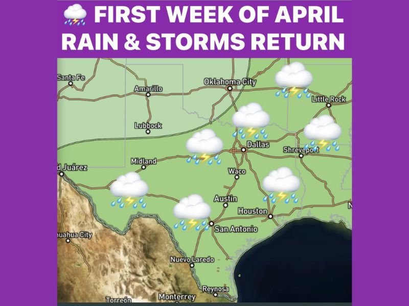
Rain and Storm Chances Increase Across Texas
The latest outlook highlights Texas as a central focus for returning storm activity, with cities such as Dallas, Austin, San Antonio, Houston, and Midland all within the projected zone of increased precipitation.
This shift marks a transition away from quieter conditions, as multiple disturbances begin moving through the region, bringing rounds of showers and thunderstorms. The developing pattern could lead to repeated rainfall events rather than isolated storms.
Oklahoma and Arkansas Also Included in Expanding Storm Zone
The active weather setup extends north into Oklahoma and east into Arkansas, including areas around Oklahoma City and Little Rock. These regions are expected to experience similar conditions, with increasing thunderstorm potential as the pattern evolves.
The presence of a more active dryline and incoming systems from the west will help support storm development across these states.
This broader coverage suggests that multiple areas across the southern Plains and nearby regions could be impacted simultaneously.
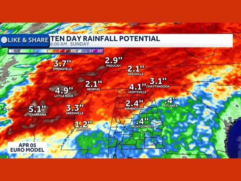
Pattern Shift Signals Above Average Precipitation
Climate outlooks are indicating a strong signal for above-average precipitation during this period. This means that rainfall totals could exceed typical early April levels across the affected states.
The combination of Pacific systems and an active dryline setup creates favorable conditions for sustained storm activity. Such patterns are common during spring but can still bring impactful weather, especially if storms repeatedly move over the same areas.
Storm Activity May Continue Into Second Week of April
Early indications show that this active pattern may persist beyond the first week of April, extending into the second week. This raises the potential for multiple rounds of storms over an extended period.
While not every day will see severe weather, the repeated chances for storms increase the likelihood of localized impacts such as heavy rain and brief strong thunderstorms. Residents should remain aware of evolving forecasts as this pattern develops further.
Typical Spring Conditions Becoming More Active
April is historically one of the wetter and windier months across this region, and the current forecast aligns with that seasonal trend.
The transition into a more dynamic weather pattern is a sign that spring is fully taking hold, bringing with it increased storm potential across the southern Plains.
Preparedness and awareness will be key as conditions shift from calm to more active in the coming days. If you’re in Texas, Oklahoma, or Arkansas, share what conditions are like in your area as this active pattern begins by visiting SaludaStandard-Sentinel.com.