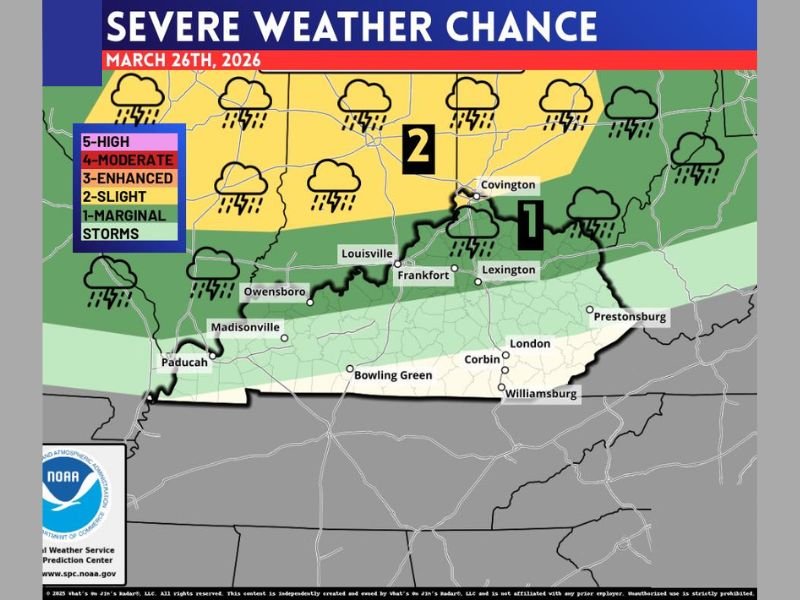
Northern Kentucky Faces Stronger Storm Risk While Rest of Kentucky Sees Gusty Thunderstorms as Cold Front Moves Through March 26
KENTUCKY — A cold front-driven storm system is expected to move across the state on March 26, bringing a line of thunderstorms with gusty winds, particularly impacting northern Kentucky where stronger storms are more likely.
While the setup includes ingredients for severe weather, the overall pattern suggests a line of storms rather than isolated, tornado-producing supercells.
Northern Kentucky Has Higher Chance for Stronger Storms
The latest outlook places northern Kentucky, including areas near Covington and along the Ohio River, in a higher risk zone for stronger thunderstorms. This region could see more organized storm activity as the system tracks east.
Storms in this area may produce stronger wind gusts and more intense lightning compared to the rest of the state. The positioning of the cold front and atmospheric dynamics favor this northern corridor for enhanced impacts. Residents in these areas should remain alert, especially during peak storm timing when conditions could briefly intensify.
Rest of Kentucky Likely to See Gusty but Less Severe Storms
Across central and southern Kentucky, including cities like Louisville, Lexington, Bowling Green, and Paducah, the threat appears lower. These regions are expected to experience thunderstorms with gusty winds but with less intensity overall.
The storm line will still bring periods of heavy rain, lightning, and brief wind gusts, but widespread severe weather is not expected in these areas. This pattern suggests a more uniform line of storms moving through rather than isolated severe cells forming across the state.
Cold Front Driving Storm Development Across the State
The primary driver of this system is a cold front pushing through Kentucky, helping to organize storms into a line. This type of setup often leads to widespread thunderstorm activity with embedded stronger segments.
While the atmosphere does support some storm strengthening, it is not highly favorable for a major severe weather outbreak. Instead, the focus remains on gusty winds and brief heavier downpours. This kind of system can still cause localized issues, including downed tree limbs and minor power disruptions.
Tornado Threat Appears Limited but Not Zero
Although the setup does not strongly favor tornado-producing supercells, isolated rotation cannot be completely ruled out. However, the overall risk for tornadoes remains low compared to other severe weather setups.
The main concern continues to be straight-line winds, which can sometimes cause damage similar to weaker tornadoes in localized areas. Staying weather-aware remains important, even when the overall threat level is lower.
Bottom Line: Stay Alert but No Major Outbreak Expected
Forecasters emphasize that while storms will move through Kentucky, this event does not currently indicate a widespread or high-end severe weather outbreak.
Northern Kentucky will have the best chance for stronger storms, while the rest of the state will likely see typical thunderstorms associated with a passing cold front.
Residents are encouraged to monitor local conditions and be prepared for brief periods of gusty winds and lightning as storms pass through. If you’re in Kentucky and experience these storms, share what conditions look like in your area by visiting SaludaStandard-Sentinel.com.