Florida, Georgia, South Carolina and North Carolina Included in NOAA’s 2026 Hurricane Track Cone Expansion Showing Inland Risk Zones
UNITED STATES — The National Hurricane Center is preparing for the 2026 hurricane season with major updates aimed at improving how storms are tracked and how warnings are issued, especially for inland communities and areas like Hawaii.
The changes include a redesigned hurricane track cone and expanded storm surge alerts, both of which are expected to significantly impact how millions of Americans receive storm warnings.
Inland Communities Now Included in Hurricane Track Cone Alerts
One of the biggest updates involves the hurricane track cone, a familiar tool used to show the projected path of a storm. Starting in 2026, this cone will now include inland U.S. areas where tropical storm and hurricane watches or warnings are in effect.
Previously, many inland communities were not clearly represented within the cone, even though they often experience strong winds and hazardous conditions after landfall. This update aims to better communicate the risks beyond coastal regions.
Officials say the change will help residents farther inland understand that dangerous wind impacts are not limited to coastal zones, especially during stronger storm systems that maintain intensity after moving inland.
New Storm Surge Alerts Introduced for Hawaii
Another key development is the introduction of storm surge watches and warnings for Hawaii. This marks a major expansion in how the National Hurricane Center communicates coastal flooding risks in the Pacific region.
Storm surge remains one of the deadliest aspects of hurricanes, and adding these alerts for Hawaii is expected to improve preparedness and evacuation decisions across the islands.
By aligning Hawaii’s alert system more closely with the mainland U.S., forecasters hope to ensure more consistent and timely messaging during tropical threats.
Updated Forecast Tools Aim to Improve Public Awareness
The updated hurricane products are designed not just for meteorologists, but for the general public. The goal is to make storm information easier to understand and more relevant to people who may not traditionally consider themselves at risk.
The hurricane cone, for example, will continue to show the probable path of a storm’s center, but officials emphasize that hazardous conditions can extend far beyond that area. Wind, rain, and flooding impacts can occur well outside the projected track.
This messaging is especially important after past storms demonstrated how inland flooding and wind damage can rival or exceed coastal impacts in some cases.
Lessons From Past Storms Driving New Changes
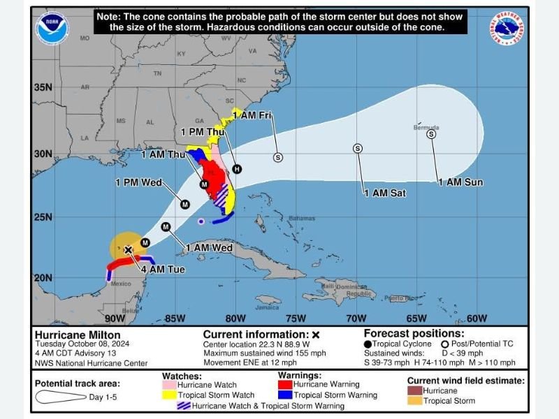
The visual preview used to demonstrate these updates has already sparked reactions due to its resemblance to past major storms, including Hurricane Milton from 2024. For many, it serves as a reminder of how quickly hurricane threats can escalate.
Emergency planners and weather officials say these updates are based on lessons learned from previous seasons, where communication gaps sometimes left inland or less-prepared regions vulnerable.
By refining how warnings are displayed and expanding coverage areas, the National Hurricane Center aims to reduce confusion and ensure more people take action when alerts are issued.
2026 Hurricane Season Could See More Accurate and Wider-Reaching Alerts
With these new tools in place, the 2026 hurricane season is expected to feature more comprehensive and geographically inclusive warning systems. This means earlier awareness for inland populations and better hazard communication for regions like Hawaii.
Officials continue to stress that while forecast tools are improving, public awareness and preparedness remain critical. Understanding the limits of forecast cones and paying attention to all warnings—not just track lines—will be key to staying safe.
As hurricane season approaches, have these updates changed how you view storm risks in your area? Share your thoughts and preparedness plans with the community at SaludaStandard-Sentinel.com.