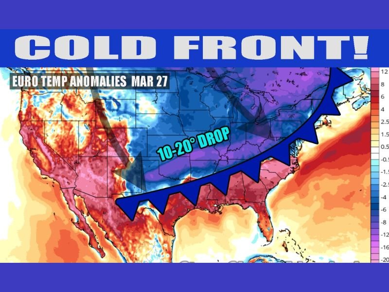
Texas, Louisiana, Mississippi, Alabama, Georgia and Carolinas to See Sharp 10 to 20 Degree Temperature Drop as Cold Front Ends March Heatwave Across Eastern U.S.
UNITED STATES — A powerful cold front is expected to sweep across the country by the end of the work week, bringing a dramatic end to the ongoing March heatwave and knocking temperatures down significantly across the South and East.
Forecast data shows temperatures could drop by as much as 10 to 20 degrees below recent levels, marking a sharp shift away from the unusually warm conditions that have dominated much of the country.
Heatwave Break Expected by End of Week
After several days of above-normal temperatures across large parts of the United States, meteorologists say relief is on the way.
The current heatwave, which has pushed temperatures well above seasonal averages, is expected to break down as the cold front advances eastward.
This transition will bring a noticeable change in conditions, especially across the central and eastern regions.
Cold Front Sweeps From Plains to East Coast
The incoming cold front is forecast to move from the central United States through the Mississippi Valley and into the Southeast and East Coast.
States including Texas, Louisiana, Mississippi, Alabama, Georgia, South Carolina, and North Carolina are expected to feel the impact as the system pushes through.
Behind the front, cooler air will replace the warm pattern, creating a more seasonable — and in some cases below-normal — temperature setup.
Temperatures Could Drop 10 to 20 Degrees
One of the most notable impacts of this system will be the sharp temperature drop.
Many areas that have been experiencing near-summer warmth will see highs fall by 10 to 20 degrees, bringing conditions closer to late March norms.
In some regions, temperatures may even dip below average for a brief period following the front’s passage.
Cooler Air Brings Temporary Relief
While the cooldown may not last long, it will provide a break from the persistent heat that has affected much of the country.
This shift is expected to feel especially noticeable in southern states, where recent temperatures have felt more like early summer than spring.
Residents can expect more comfortable conditions once the front moves through.
Pattern Remains Active Moving Forward
Even as the heatwave ends, the overall weather pattern remains active, with additional systems possible in the days ahead.
Meteorologists will continue monitoring for further temperature swings and potential storm development along the front.
The transition period could also bring unsettled weather in some areas as the front moves across the region.
If you’re noticing the temperature shift or preparing for the cooldown in your area, share your experience with us. Stay connected with SaludaStandard-Sentinel.com for continued updates on changing weather patterns across the United States.