Colorado Front Range Snow Bands Could Suddenly Slam Denver and I-25 Corridor Overnight as Rare CSI Setup Triggers Localized Snurfal
DENVER, COLORADO — Drivers along Colorado’s Front Range could face sudden and highly localized bursts of snowfall overnight as meteorologists warn of a rare atmospheric setup capable of producing narrow but intense snow bands across the Denver metro area and along the Interstate-25 corridor.
Forecasters say the unusual pattern is being driven by a phenomenon known as Conditional Symmetric Instability (CSI), which can create isolated corridors of heavy snowfall while nearby areas remain relatively clear. The snow bands are expected to develop as a powerful weather system continues to impact large parts of the United States.
Rare Atmospheric Setup Behind the Snow Bands
Meteorologists say the Front Range region — including Denver, Fort Collins, Colorado Springs and nearby foothills — is currently positioned beneath a strong north-to-south oriented jet stream on the backside of a large atmospheric trough.
This same storm system is responsible for producing blizzard conditions in parts of the Midwest and severe storms across the eastern United States.
Because of a process related to Bernoulli’s principle, the strong jet stream overhead is creating localized zones of rising air near the surface. When this lift occurs in the presence of cold air and moisture, it can produce narrow streaks of snow known as CSI bands.
Snow Could Vary Dramatically Over Short Distances
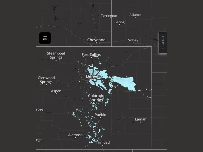
One of the defining characteristics of CSI snow bands is how extremely localized they can be. Meteorologists say the difference between clear skies and near-whiteout conditions can occur within just a mile or two when these bands develop.
In some areas along the I-25 corridor and eastern plains, drivers may suddenly encounter bursts of heavy snowfall while nearby neighborhoods remain largely unaffected. This type of localized snowfall is sometimes referred to informally as “snurfal,” a combination of snow and sudden bursts of intense precipitation.
Even Light Snow Could Cause Travel Problems
Although snow accumulation totals may not appear particularly impressive overall, forecasters warn that even small amounts of snow could quickly create hazardous road conditions. Temperatures across the region remain well below freezing, which means any snowfall could stick quickly to roads and highways.
Transportation officials note that many winter crashes occur during storms producing two inches of snow or less, especially when snow falls suddenly during busy travel periods.
Monday Morning Commute Could Be Impacted
The biggest concern for commuters will be the possibility that narrow snow bands develop during the early morning hours, just as traffic increases across the Denver metro region.
Drivers traveling along Interstate 25 and nearby highways could experience rapidly changing road conditions if one of the CSI bands moves through. Even brief bursts of snow can reduce visibility and create slick road surfaces, increasing the risk of accidents.
Snow Bands May Continue While Jet Stream Remains Overhead
Meteorologists say it is difficult to determine exactly when the snow bands will end because they depend on the position of the jet stream.
As long as the strong upper-level winds remain over Colorado, additional CSI bands could continue developing intermittently. Some bands have already been observed forming across parts of the Front Range overnight, indicating the pattern is already active.
Residents Advised to Use Caution on Roads
Weather officials are advising residents across the Denver region and surrounding areas to remain cautious if traveling overnight or early Monday morning. Drivers should allow extra time, reduce speeds on potentially slick roads, and remain alert for rapidly changing visibility conditions.
If weather impacts your community, share local conditions and updates with the newsroom at SaludaStandard-Sentinel.com as meteorologists continue tracking this unusual snow setup.