Central and Eastern North Carolina, Southern Virginia Under Moderate Level 4 Severe Storm Risk Monday With Damaging Winds and Tornadoes Possible
NORTH CAROLINA — Meteorologists are warning that central and eastern parts of North Carolina could see a higher-end severe weather outbreak Monday, as a powerful cold front moves across the state and creates conditions favorable for damaging winds and possible tornadoes.
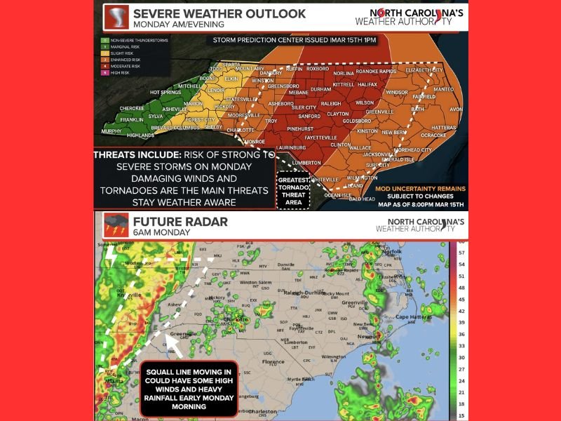
The Storm Prediction Center has placed much of central North Carolina extending into southern Virginia under a Level 4 out of 5 “Moderate Risk” for severe weather, a relatively rare designation that signals the potential for widespread impactful storms.
Most of the remaining areas across central and eastern portions of the state fall under a Level 3 Enhanced Risk, while western areas are in lower risk categories.
Strong Cold Front and Wind Shear Fueling Storm Development
Forecasters say a very strong cold front combined with powerful upper-level winds will move across North Carolina during the day Monday.
As warm and unstable air interacts with the advancing front, thunderstorms are expected to develop and organize into a line of storms that will sweep from west to east across the state.
Meteorologists say the level of atmospheric instability — often measured as Convective Available Potential Energy (CAPE) — will play a key role in determining how intense storms become.
If more sunshine develops during the morning and early afternoon hours, the atmosphere could become more unstable, increasing the likelihood of stronger storms and potentially tornado-producing cells.
Damaging Straight-Line Winds Expected to Be Main Threat
According to the forecast outlook, the primary hazard will be damaging straight-line winds produced by a line of storms moving through the state Monday morning into the afternoon.
Wind gusts associated with these storms could be strong enough to knock down trees, damage roofs, and cause scattered power outages across communities.
In addition to the storm-related winds, forecasters expect gusty winds of 30 to 40 miles per hour statewide even outside thunderstorms, making conditions blustery throughout the day.
Tornado Risk Focused in Central and Eastern Areas
While damaging winds are expected to be the most widespread hazard, meteorologists warn that tornadoes are also possible, particularly in the areas under the Level 3 and Level 4 risk zones.
Some weather models indicate that discrete thunderstorms could develop ahead of the main line of storms, which would increase the potential for tornado formation.
These storms could develop late Monday morning into the afternoon across parts of central and eastern North Carolina, where atmospheric conditions may be most favorable.
Storm Timing From Morning Into Evening
Forecast radar projections show storms entering western portions of the state during the morning hours, before moving eastward through the Piedmont and coastal plain during the afternoon.
Cities including Charlotte, Raleigh, Fayetteville, Wilmington, and Greenville could experience thunderstorms at different points throughout the day as the storm line advances. By late afternoon or early evening, the severe weather threat is expected to shift toward the coast before gradually weakening.
Residents Encouraged to Stay Weather Aware
Forecasters emphasize that even within higher risk zones, not every location will experience severe storms, but conditions will support storms capable of producing damaging weather.
Residents are encouraged to remain weather-aware, monitor forecasts, and ensure they have multiple ways to receive weather alerts if warnings are issued. Emergency officials also advise reviewing severe weather safety plans in advance in case conditions worsen quickly.
If severe storms impact your area Monday, share local conditions and updates with the newsroom at SaludaStandard-Sentinel.com so readers across the region can stay informed as the storm system moves through.