Warm Front Along I-94 Sparks Overnight Severe Storm Threat With Tornadoes, Damaging Winds and Large Hail Possible
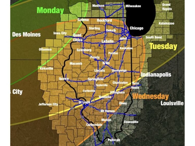
MIDWEST UNITED STATES — Meteorologists are tracking a developing severe weather setup Tuesday evening as a warm front positioned along Interstate 94 creates conditions favorable for thunderstorms capable of producing tornadoes, damaging winds, and large hail.
Weather analysis indicates that areas along and south of the I-94 corridor face the greatest risk for severe storms overnight. Forecasters warn that the threat could continue into the early morning hours, potentially lasting until around 4 a.m. as the storm system evolves.
The developing pattern places several Midwestern communities in a zone where warmer, unstable air is colliding with cooler air farther north, a setup that often leads to strong and organized thunderstorms.
Warm Front Creates Boundary for Severe Weather
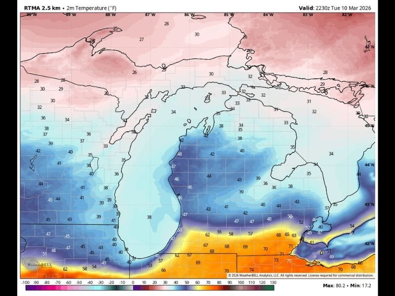
Meteorologists say the warm front currently positioned along I-94 is acting as a dividing line between two different air masses. North of the boundary, cooler air dominates across portions of Michigan and surrounding areas. Temperatures in these regions remain significantly lower, limiting the amount of surface energy available for severe storms.
However, conditions south of the front are far more favorable for storm development. Warmer air with higher instability is spreading across parts of the Midwest, providing the fuel thunderstorms need to intensify. This contrast between the warm and cool air masses is a key ingredient in severe weather formation.
Tornado Threat Focused South of Interstate 94
Forecasters say the most concerning severe weather threat lies south of the I-94 corridor. Within this region, storms could produce several hazards including large hail, damaging wind gusts, and the possibility of tornadoes. The risk is expected to persist overnight as thunderstorms continue to develop along the warm front.
Meteorologists emphasize that storms interacting with this boundary often become more organized, increasing the chance for rotating thunderstorms capable of producing tornadoes. Areas closer to the warm front typically experience the strongest storm dynamics, which is why communities along and south of the boundary are being closely monitored.
Large Hail Primary Concern North of the Front
Conditions north of the warm front tell a different story. Because cooler air remains in place, the environment there is less supportive of tornado formation. Instead, forecasters say large hail is the main severe weather threat across these northern areas.
Some storms may also produce isolated damaging wind gusts, but the overall tornado risk remains low north of I-94 due to limited surface-based storm energy. This temperature difference across the region can often shape how storms behave and determine which hazards are most likely.
Forecast Remains on Track Overnight
Meteorologists say the forecast scenario remains consistent with earlier expectations, with storms likely continuing to form and intensify overnight. As the warm front holds near I-94, the boundary will likely remain a focal point for thunderstorm development. This could allow storms to repeatedly form along the same corridor as the night progresses. Forecasters will continue monitoring radar and atmospheric conditions closely as storms evolve across the Midwest.
Residents in areas near and south of the warm front are encouraged to remain alert for weather warnings through the overnight hours, especially since severe storms can develop quickly after dark. Readers who are experiencing storms in their communities can share updates and follow the latest weather coverage at SaludaStandard-Sentinel.com.