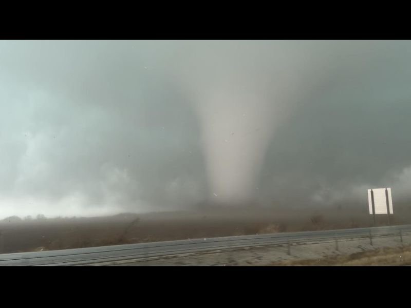
Kankakee, Illinois Tornado Reported as Destructive Funnel Passes Close Range, Damaging Buildings and Shattering Windows
KANKAKEE, ILLINOIS — A powerful tornado was reported near the city of Kankakee as severe storms moved through the region, with witnesses describing a destructive funnel passing extremely close and causing significant damage, including shattered windows and debris.
Images and reports from the area show a large tornado touching down across open land near a roadway, with the funnel clearly visible beneath dark storm clouds. The storm system appeared to be part of a larger outbreak of severe weather moving across parts of Illinois. Early eyewitness accounts suggest the tornado passed close enough to buildings and vehicles to cause structural damage and break multiple windows.
Eyewitness Reports Describe Close-Range Tornado Impact
People who experienced the storm firsthand described a frightening encounter with the tornado as it moved through the area. One report from the scene said the tornado passed at extremely close range, with the intense wind force blowing out several windows in nearby structures. The violent winds also kicked up dust and debris as the funnel tracked across the landscape.
Photos taken during the storm show the tornado extending from the storm cloud down to the ground, with a wide condensation funnel and a debris cloud forming near the base. Such storms can produce rapidly changing conditions, and tornadoes may intensify quickly as they move across open terrain.
Severe Storm System Moving Across Illinois
The tornado occurred as a powerful storm system swept across parts of Illinois, bringing conditions favorable for rotating thunderstorms capable of producing tornadoes.
Meteorologists often watch for these setups when warm, unstable air near the surface interacts with strong winds higher in the atmosphere. This combination can allow thunderstorms to rotate and produce tornadoes, especially when storm cells become organized. The storms affecting Kankakee were part of a broader pattern of severe weather capable of producing damaging winds, hail, and tornadoes across portions of the Midwest.
Damage Reports and Safety Concerns
Initial reports from the area suggest that the tornado caused localized damage, particularly to windows and possibly other structures caught in the storm’s path. Strong tornadoes can generate wind speeds exceeding 100 miles per hour, which is enough to shatter glass, damage roofs, and toss debris across roads and fields.
Emergency responders and weather officials typically assess damage after storms pass to determine the tornado’s strength and exact path. Those evaluations help confirm whether the tornado was weak, moderate, or more destructive based on structural damage and debris patterns.
Residents Urged to Remain Weather Aware
Severe weather events like this highlight the importance of staying alert during storm outbreaks. Tornadoes can develop quickly and may strike with little warning, especially when embedded within larger storm systems.
Residents across Illinois and nearby regions are encouraged to monitor weather alerts and seek shelter immediately if tornado warnings are issued. Meteorologists also remind residents that sturdy buildings, interior rooms, and basements provide the best protection during tornado emergencies.
As storm surveys and damage assessments continue, more information may emerge about the tornado’s strength and the areas most heavily impacted. Readers who witnessed the storm or experienced damage in their communities can share their experiences and follow ongoing updates at SaludaStandard-Sentinel.com.