Indiana Braces for Overnight Severe Weather Tuesday as Strong Tornadoes, Hail and Damaging Winds Become Possible
INDIANA — Meteorologists are warning residents across Indiana to prepare for a potentially active round of severe weather Tuesday evening through early Wednesday morning, with storms capable of producing tornadoes, damaging winds, large hail, and heavy rain.
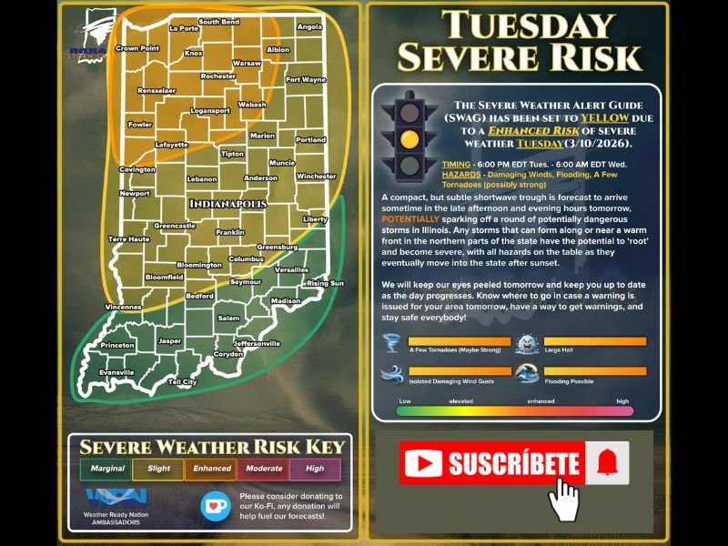
Forecast guidance shows the entire state of Indiana under some level of severe weather risk, ranging from marginal to enhanced categories depending on location. Forecasters say the highest threat for stronger storms may develop across northern and northwestern portions of the state, where atmospheric conditions could support rotating thunderstorms.
Three Levels of Severe Weather Risk Across Indiana
According to the latest forecast outlook, Indiana sits beneath three separate severe weather risk categories, meaning storms could impact nearly every part of the state.
The risk levels include:
- Marginal Risk (Level 1 of 5) across parts of southern Indiana
- Slight Risk (Level 2 of 5) across central sections of the state
- Enhanced Risk (Level 3 of 5) across northern and northwestern Indiana
Communities in the enhanced risk zone could face the greatest chance for stronger storms, including tornado potential.
Storm Timing Could Extend Through the Night
Meteorologists say storms may begin developing Tuesday evening and continue into the overnight hours. Current projections place the main window for severe weather from around dinner time Tuesday until approximately 5 a.m. Wednesday.
Overnight storms can pose a greater danger because many people are asleep when warnings are issued, reducing reaction time if severe weather develops.
Tornadoes, Large Hail and Damaging Winds Possible
Forecasters warn that storms developing in this environment could bring multiple severe weather hazards, including:
- Tornadoes, possibly strong in isolated areas
- Large hail capable of damaging vehicles and property
- Damaging straight-line winds
- Heavy rainfall that could lead to localized flooding
- Frequent lightning within stronger storm cells
Because the system could produce multiple storm types, meteorologists say residents should be prepared for rapidly changing conditions during the evening and overnight hours.
Residents Urged to Prepare Before Storms Arrive
Officials are encouraging residents to take precautions before the storms begin. Weather experts recommend ensuring that emergency alerts are enabled on smartphones and having multiple ways to receive warnings, such as NOAA weather radios.
Residents should also identify a safe shelter location in their homes, preferably a basement or an interior room on the lowest floor away from windows. Charging electronic devices, keeping flashlights nearby, and ensuring all household members understand the safety plan are also recommended steps ahead of severe weather.
Meteorologists emphasize that while forecasts may change as new data becomes available, preparing in advance is the best way to stay safe during overnight severe weather events.
Stay with SaludaStandard-Sentinel.com for continued updates as meteorologists track developing severe storms expected to move across Indiana Tuesday night.