Severe Storms Expected to Ignite Between 6–8 PM Across Oklahoma and Northwest Arkansas With Threat of Large Hail, Damaging Winds and Possible Tornadoes
OKLAHOMA, ARKANSAS — Forecasters are warning that severe thunderstorms could rapidly develop Friday evening across parts of Oklahoma and northwest Arkansas, with storms expected to ignite between 6 p.m. and 8 p.m. as atmospheric conditions become favorable for severe weather.
Weather models show a developing line of storms moving across the region that could bring large hail, damaging winds, and the possibility of isolated tornadoes as the system intensifies.
Storms Expected to Develop During the Evening Hours
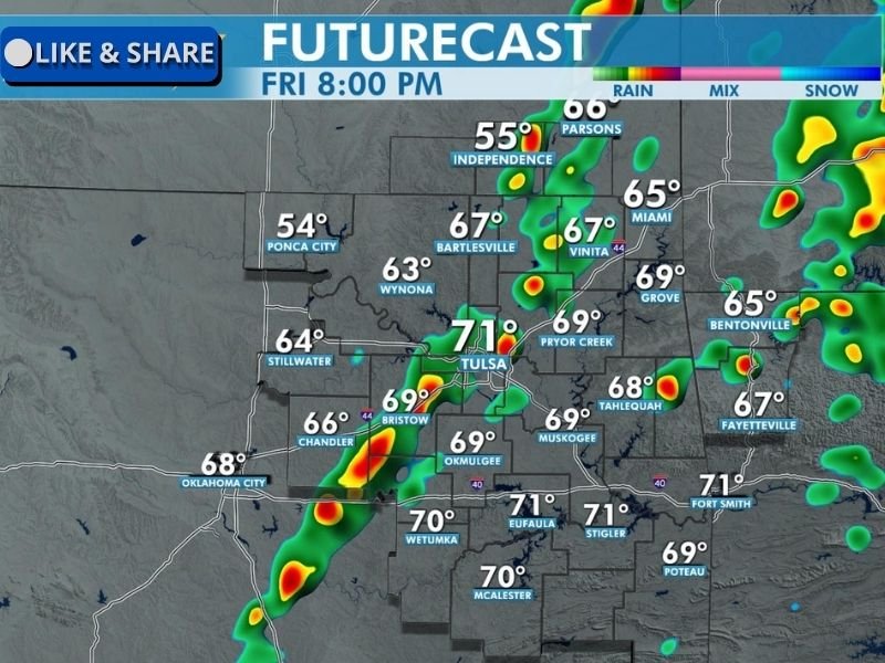
According to the latest future radar projections, scattered storms may begin forming late Friday afternoon before becoming more organized during the early evening.
The most active storm development is expected between 6 p.m. and 8 p.m., when conditions may allow thunderstorms to strengthen into severe cells. Cities including Tulsa, Bartlesville, Pryor Creek, Vinita, Miami, Bentonville, Fayetteville, and Fort Smith fall within the zone where storms could develop or move through during the evening.
Large Hail and Damaging Winds Are Major Threats
Meteorologists say large hail and strong winds will be the primary hazards associated with these storms.
Some storms could produce hail large enough to damage vehicles, rooftops, and crops, while wind gusts from stronger thunderstorms may cause downed tree limbs and scattered power outages.
Residents are being encouraged to secure outdoor objects and monitor weather alerts as storms approach.
Isolated Tornadoes Also Possible
Although tornado risk is considered lower than the hail and wind threat, forecasters say a few tornadoes cannot be ruled out if storms develop strong rotation.
Supercell storms that form ahead of the main storm line could briefly produce tornadoes before merging into a larger line of thunderstorms.
Because severe weather can develop quickly in these situations, meteorologists stress the importance of staying aware of rapidly changing weather conditions.
Temperatures and Humidity Helping Fuel Storms
Forecast temperatures across the region are expected to remain in the mid-to-upper 60s and low 70s, creating an environment supportive of storm development.
Cities such as Tulsa, Eufaula, McAlester, and Fort Smith are expected to see warm and humid conditions that could help storms intensify during the evening hours.
Residents Urged to Stay Weather-Aware
Emergency officials encourage residents across the region to monitor local forecasts and be prepared for sudden severe weather warnings. People should ensure they have multiple ways to receive alerts, especially if storms continue into the evening hours.
Severe storms can develop quickly during spring weather patterns, and forecasters will continue monitoring the system closely as it moves across the Southern Plains. Have severe storms recently impacted your community? Share your weather experiences or photos with readers at SaludaStandard-Sentinel.com.