Complex Winter Storm Brings Rapid Switch From Rain to Freezing Rain, Sleet and Snow Across New England Overnight
NEW ENGLAND — Meteorologists are warning that a complicated winter storm system is developing across parts of New England, bringing a messy mix of rain, freezing rain, sleet, and snow overnight as temperatures fluctuate through different atmospheric layers.
Forecasters say the system is difficult to predict because warmer air in the middle levels of the atmosphere is sandwiched between colder air above and below, creating conditions where precipitation types may change repeatedly throughout the night.
Rain to Ice to Snow Expected Across the Region
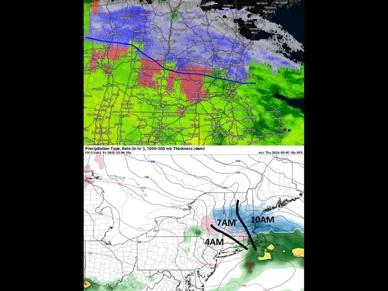
According to the latest evening update, the storm will likely create different weather conditions depending on location. Areas farther south are expected to remain mostly rain, while locations farther north are more likely to see steady snowfall.
The middle corridor between those zones could experience rapid transitions between rain, freezing rain, sleet, and snow, sometimes switching back and forth as the storm evolves. Meteorologists say the changeover has already begun in the upper atmosphere, though it may take time for those changes to reach ground level.
Ice Accumulation and Snow Both Possible
Forecast estimates suggest a wide range of possible outcomes across the region, making this storm particularly challenging to predict. Some areas may see 0 to 2 inches of snow, while others could receive 3 to 6 inches depending on how the storm develops overnight.
In addition to snow, forecasters say light ice accumulation is also possible, potentially reaching just under half an inch in some areas. Even a thin layer of ice can make roads, sidewalks, and power lines hazardous.
Highly Variable Conditions Expected
Meteorologists emphasize that the storm’s unusual structure means precipitation types could change multiple times during the same event.
For some communities, the night could begin with rain before transitioning to freezing rain and sleet, then changing to snow. Other areas may briefly see snow before returning to rain again.
Because the middle section of the storm system will likely receive the heaviest precipitation, residents there could experience the most dramatic changes in weather conditions.
Morning Conditions Could Look Very Different
Forecasters say some communities may wake up to very little accumulation, while others could see several inches of snow mixed with ice and sleet. There is also the possibility of standing water and puddles from melting precipitation, depending on how temperatures shift overnight.
Weather models indicate the storm should gradually move out by mid-morning, with precipitation tapering off between roughly 7 a.m. and 10 a.m. in many areas.
Residents Urged to Stay Prepared Overnight
Because conditions may change quickly, officials recommend residents prepare for multiple weather scenarios overnight. Drivers should be cautious of icy roads, and residents should stay alert for updates as meteorologists refine the forecast.
The unusual structure of the storm means even small temperature shifts could dramatically change how much snow, ice, or rain a particular community receives. Have you experienced rapidly changing winter weather like this in your area? Share your photos or experiences with readers at SaludaStandard-Sentinel.com.