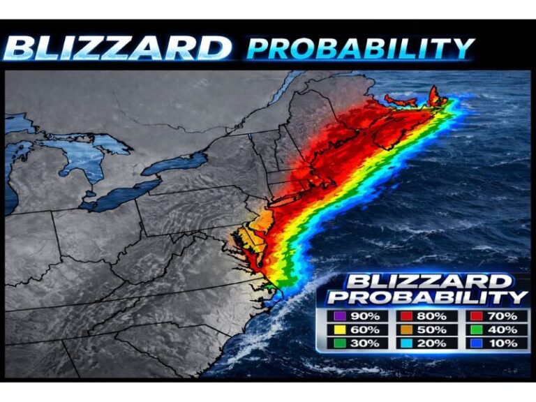
New York, New Jersey, Connecticut, Massachusetts Brace for “Snowicane” Nor’easter as Bomb Cyclone Spins Offshore With Hurricane-Force Gusts
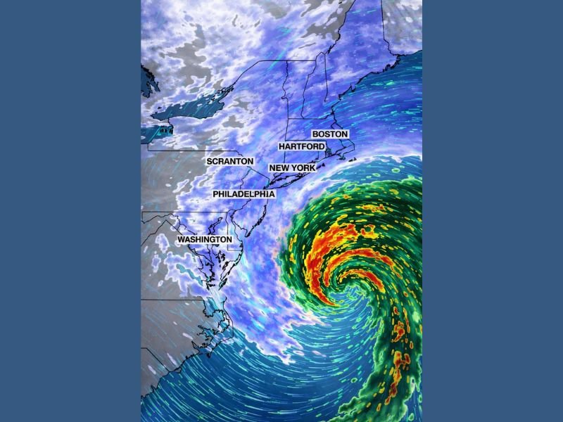
UNITED STATES — A massive Nor’easter churning offshore is being described as a “snowicane” as it hammers the Mid-Atlantic and Northeast with blizzard conditions, intense snowfall, and wind strong enough to mimic hurricane impacts along the coastline. Satellite-style radar imagery shows a tightly wound storm with a clearly defined, eye-like center offshore while heavy snow bands wrap into major population corridors from the Washington area through Philadelphia, New York City, Hartford, and Boston.
The storm’s strength is being linked to rapidly falling pressure near 970 mb, a level forecasters note can be comparable to a Category 2 hurricane in terms of intensity — even though this remains a non-tropical system.
A 1,200-Mile-Wide Storm With an Eye-Like Center Is Driving Dangerous Conditions
The radar presentation highlights the sheer size of the system — described as roughly 1,200 miles wide — as it rotates off the East Coast. That broad circulation matters because it can prolong impacts: heavy snow bands can pivot over the same areas, while the wind field expands far from the storm’s center.
Communities closer to the coast are especially vulnerable to the combination of strong winds and heavy snow, which can create whiteout visibility and fast-building drifts that block roadways.
Snow Totals Over 24 Inches Possible Across Parts of the Northeast
The latest storm messaging suggests snow totals over 24 inches may stack up in multiple locations, particularly where the most intense bands lock in. The corridor of heaviest snow shown on the radar feed aligns with some of the most densely traveled parts of the region, meaning even short disruptions can quickly cascade into widespread closures and emergency response delays.
In storms like this, conditions can change street-by-street depending on where the strongest band sets up — and that can determine whether an area sees a foot of snow or two feet-plus.
Hurricane-Force Gusts Along the Coast Raise the Risk of Outages and Damage
The bomb cyclone is also packing hurricane-force wind gusts near the coast, with the potential for damage even away from shore where gusts remain strong. When wind this intense hits during heavy snowfall, the biggest dangers often become near-zero visibility, deep drifting, and power failures from tree limbs snapping under snow load.
Officials frequently urge residents to treat this kind of storm as a stay-put event, because travel becomes risky and rescue response can be slowed when roads clog or disappear under drifting.
Why Forecasters Say This Could Be a “History-Making” Blizzard
The combination of an eye-like structure offshore, very low pressure, widespread heavy snow, and extreme coastal wind is why the storm is being framed as a rare and potentially historic event. Even after snowfall eases, the aftermath can include blocked roads, extended power restoration, and hazardous cleanup conditions in freezing temperatures.
If you’re in New York, New Jersey, Connecticut, or Massachusetts, what are you seeing right now — heavy bands, whiteouts, or outages starting to spread? Share what’s happening in your area and join the conversation at SaludaStandard-Sentinel.com.