North Carolina and Southern Virginia Could See Rain, Then a Late-Sunday Snowflake Surprise in the Northeast
NORTH CAROLINA — A developing low-pressure system is expected to move through tonight into Sunday, bringing periods of rain for much of the state before colder air arrives late in the day. While most communities should stay wet rather than wintry, parts of northeast North Carolina may see snowflakes mixing in Sunday evening, mainly northeast of Raleigh, as temperatures drop and moisture wraps around the storm.
The overall message: plan for a damp, changeable Sunday, then keep an eye on the far northeast late Sunday night—especially if you’re traveling toward the Virginia line.
Low-Pressure System Brings Rain Tonight and On-and-Off Showers Sunday
Forecast discussion tied to the latest radar projections points to rain developing tonight and continuing on and off through Sunday. The Sunday pattern looks unsettled rather than a single solid line of rain, which means some towns may get steady showers while others bounce between drizzle, breaks, and heavier bursts.
By Sunday afternoon and evening, the low is expected to pull more moisture back into the region, increasing coverage again—especially across central and eastern North Carolina.
Cold Air Arrives Late, Keeping Mountain Snow on the Table
As colder air filters in behind the system, snow in the higher elevations of the North Carolina mountains remains the more reliable wintry outcome. In the mountains, temperatures are typically cold enough for snow to develop even when lower elevations stay rain.
This is important for anyone traveling across higher passes, where slick spots can develop quickly if precipitation changes over while temperatures are dropping.
Northeast North Carolina Could See Snowflakes Sunday Evening
Outside the mountains, the only place with a meaningful chance to see wintry flakes is northeast North Carolina, especially areas northeast of Raleigh. The timing highlighted is Sunday evening, when colder air is finally chasing the departing moisture.
That said, temperatures are expected to be marginal, which is why significant accumulation is not the forecast expectation. Still, a brief rain-to-flakes changeover can surprise drivers if road temperatures cool fast after sunset.
Light Accumulation Possible on Elevated Surfaces Near the VA Line
While widespread totals are not expected, the forecast notes that light accumulation on elevated surfaces can’t be ruled out in parts of NE North Carolina, particularly as you head into southern Virginia. Bridges, overpasses, and raised decks cool faster than ground-level pavement—so those are the spots that can get slick first if flakes begin sticking.
If you live in the far northeast corner of the state or have plans toward the Virginia line Sunday night, it’s smart to watch for updated statements in case the storm track or temperature profile shifts slightly colder.
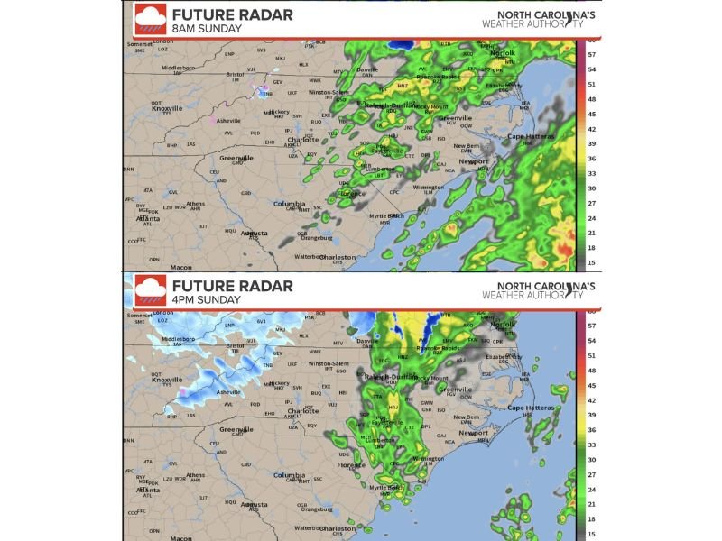
What the Sunday Evening Radar Timing Suggests
The future radar snapshots show a progression where precipitation remains active through the day, then the colder air presses in during the evening and late-night hours. The key takeaway is the timing: the best window for any mix or flakes in the northeast appears to be late Sunday into Sunday night, after the daytime rain pattern has already settled in.
Are you seeing rain start up where you live, or are you in northeast North Carolina watching for a possible late snow mix? Share what’s happening in your area and what you’re preparing for at SaludaStandard-Sentinel.com.