Forecasters Warn This Is Not “Just Another Snowstorm” as 1–3 Feet and 85-MPH Gusts Threaten Mid-Atlantic and Northeast
UNITED STATES — Forecasters are urging residents from the Mid-Atlantic into the Northeast to treat this winter storm as a high-end, dangerous event, warning that preparations should be happening now as the region faces the potential for widespread 1–3 feet of snow and damaging wind gusts late Sunday into Monday.
The concern is not just how much snow falls, but how quickly conditions could turn life-threatening once strong winds arrive—creating near-zero visibility, significant drifting, and travel shutdowns in the hardest-hit corridors.
Why Forecasters Say This Storm Could Turn Dangerous Fast
Weather messaging tied to the latest guidance stresses that people may be underestimating the potential impacts. A powerful combination of heavy snowfall rates and intensifying winds can cause visibility to collapse quickly, even on major highways and in metro areas that normally handle winter weather.
As snow piles up and wind increases, roads can become impassable in a short period of time—especially on bridges, coastal routes, and open stretches where blowing snow can drift back over plowed lanes.
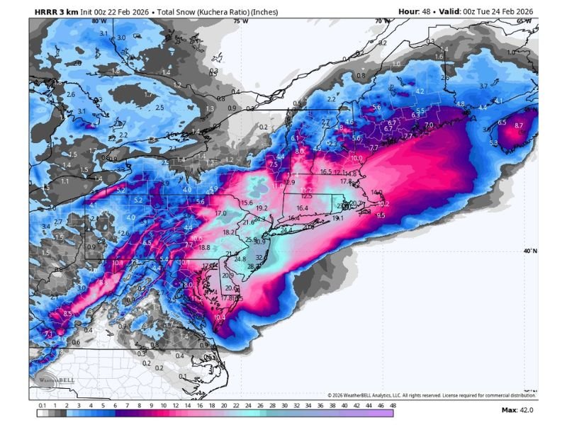
Snowfall Forecast: 1–3 Feet Possible With Localized Totals Over 24 Inches
Model guidance shows a broad, high-impact snow swath stretching from parts of the Mid-Atlantic into New England. Within that zone, some locations could see totals reaching 1 to 3 feet, with pockets—especially across parts of New Jersey—capable of exceeding 24 inches if the current storm track holds.
The map depiction accompanying the forecast highlights a concentrated band of heavier totals near the coastal corridor, where changes in storm position can mean the difference between heavy snow and truly extreme snowfall totals.
Wind Gusts 55–85 MPH Could Create Blizzard Conditions and Long-Lasting Impacts
On top of heavy accumulation, forecasters are warning about 55–85 mph wind gusts late Sunday into Monday. That level of wind can turn heavy snow into blizzard conditions in spots, producing near-whiteout visibility and dangerous drifting that makes it difficult for road crews and emergency responders to keep up.
Power outages and closures are increasingly likely during and after the storm, particularly where wind-driven snow loads tree limbs and power lines. Even after snowfall eases, drifting can continue to re-cover roads and block driveways.
Timing: Late Sunday Into Monday Is the Critical Window
The highest-risk period is expected late Sunday through Monday morning, when wind and snow could peak together. That timing is why forecasters are emphasizing that this is not a “wait and see” situation—once conditions deteriorate, travel may not be possible.
What are you seeing where your friends or family live in the Mid-Atlantic or Northeast—are people stocking up, changing travel plans, or already seeing early impacts? Share your thoughts and local updates with SaludaStandard-Sentinel.com.