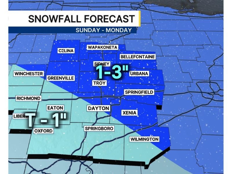
Dayton, Ohio Snow Forecast Tightens: 1–3 Inches Possible North and East Sunday Night Into Monday With Slick Spots Likely
OHIO — Forecasters are narrowing in on a higher-snow zone around the Dayton region for Sunday into Monday, with parts of the area north and east of Dayton now projected to see 1 to 3 inches of snow as colder air settles in.
Snow Totals Highest North and East of Dayton
The updated snowfall forecast highlights a focused corridor where snow showers could become more persistent Sunday night into Monday. Communities in the higher-total zone include areas around Sidney, Troy, Urbana, Bellefontaine, and Wapakoneta, where the most consistent snowfall could push totals into that 1–3 inch range.
While this is not expected to be a major snowstorm, even a few inches can create travel headaches—especially overnight and early morning.
Lower Totals Expected South and West of the City
South and west of Dayton, totals are expected to be lighter as snow showers become less persistent and more scattered. Some of the lower-snow locations shown in the forecast include areas near Richmond, Eaton, Oxford, and surrounding communities, where snowfall could stay closer to a dusting up to around 1 inch.
That lighter snowfall may sound minor, but it can still create isolated slick patches when temperatures fall.
The Bigger Issue May Be Slick Spots Overnight Into Monday
The forecast notes that the main concern is not deep accumulation—it’s road temperatures and air temperatures cooling Sunday night, which could allow a couple slick spots to develop. Bridges, ramps, shaded roads, and less-treated secondary streets often become hazardous first when snow falls during a temperature drop.
Drivers heading out late Sunday night or early Monday should be prepared for changing conditions and reduced traction in spots.
Not a Major Snow, But Enough to Disrupt Plans
Forecasters emphasized this system is not expected to produce a major snow event. However, it could still be inconvenient, particularly for commuters, school transportation routes, and anyone traveling during the overnight hours when road treatments may lag behind the timing of the snow.
What to Watch Through the Weekend
The forecast outlook indicates meteorologists will continue monitoring trends through the weekend as the snow band becomes clearer. The main adjustments could involve where the 1–3 inch stripe sets up and how long snow showers persist overnight.
If you’re in the Dayton area or north and east of the city, are you expecting more snow where you live — or do you think it stays lighter? Share what you’re seeing and join the discussion at SaludaStandard-Sentinel.com.