Alabama Night Storms Track East-Northeast at 50 MPH, Bringing Heavy Rain and 30+ MPH Winds Through Late Friday
ALABAMA — Two locally heavy storm clusters were moving east-northeast at roughly 50 mph late Friday night, bringing periods of heavy rain, gusty winds over 30 mph, and scattered lightning to parts of north Alabama through about 11 p.m.
Storms Target Several North Alabama Counties Through 11 P.M.
The late-evening update indicated the strongest impacts were expected across Cullman, Walker, Winston, Fayette, and Blount Counties, where downpours and brief bursts of wind could make travel difficult. While the storms were not expected to be long-lasting in any one spot, the faster movement means conditions can change quickly from “just rain” to a sudden heavy downpour and gusty winds.
Timing Windows Show When Heavier Rain Could Arrive
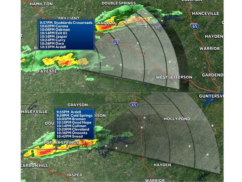
Radar timing estimates late Friday suggested the northern storm line could reach areas including Studdards Crossroads, Corona, Oakman, Jasper, Curry, Dora, and Ardell between roughly 9:57 p.m. and 10:33 p.m. A second line farther south was timed to move through Ardell, Cold Springs, Bremen, Good Hope, Cullman, Cleveland, Oneonta, and Snead from about 9:55 p.m. to 10:42 p.m.
These estimates can shift as storms strengthen or weaken, but they provide a useful snapshot of the late-night progression as the storms push east.
Severe Weather Not Likely, But Brief Rough Spots Are Possible
Forecasters noted that widespread severe weather was not very likely overnight. Still, some storms could become locally intense for short periods, especially where heavier rain bands form. The main concerns remain downpours that reduce visibility, localized ponding on roads, and gusty winds that can knock around loose outdoor items.
More Rain and Storm Activity Could Develop Overnight Into Saturday
The weather setup could stay active beyond the initial round, with more development possible overnight into Saturday morning. That doesn’t necessarily mean severe storms, but it does mean some communities may see additional showers or thunder after the first heavier cells move through.
Drivers are urged to slow down in heavy rain, watch for water collecting in low spots, and give extra distance to other vehicles during sudden visibility drops.
If you’re in Cullman, Walker, Winston, Fayette, or Blount County, did the storms hit hard where you live — or did they mainly pass by as light rain? Share what you’re seeing and join the conversation at SaludaStandard-Sentinel.com.